Cagayan de Tawi-Tawi
| {{#if: | | {{#invoke:WLink|getArticleBase}} }}
{{#if: |
|||||||||||||||||||||||||||||||||||||||||||||||||||||||||||||||||||||||||||||||||||||||||||||||||||||||||||||||||||||||||||||||||||||||||||||||||||||||||||||||||||||||||||||||||||||||||||||||||||||||||||||||||||||||||||||||||||||||||||||||||||||||||||||||||||||||||||||||||||||||||||||||||||||||||||||||||||||||||||||||||||
|---|---|---|---|---|---|---|---|---|---|---|---|---|---|---|---|---|---|---|---|---|---|---|---|---|---|---|---|---|---|---|---|---|---|---|---|---|---|---|---|---|---|---|---|---|---|---|---|---|---|---|---|---|---|---|---|---|---|---|---|---|---|---|---|---|---|---|---|---|---|---|---|---|---|---|---|---|---|---|---|---|---|---|---|---|---|---|---|---|---|---|---|---|---|---|---|---|---|---|---|---|---|---|---|---|---|---|---|---|---|---|---|---|---|---|---|---|---|---|---|---|---|---|---|---|---|---|---|---|---|---|---|---|---|---|---|---|---|---|---|---|---|---|---|---|---|---|---|---|---|---|---|---|---|---|---|---|---|---|---|---|---|---|---|---|---|---|---|---|---|---|---|---|---|---|---|---|---|---|---|---|---|---|---|---|---|---|---|---|---|---|---|---|---|---|---|---|---|---|---|---|---|---|---|---|---|---|---|---|---|---|---|---|---|---|---|---|---|---|---|---|---|---|---|---|---|---|---|---|---|---|---|---|---|---|---|---|---|---|---|---|---|---|---|---|---|---|---|---|---|---|---|---|---|---|---|---|---|---|---|---|---|---|---|---|---|---|---|---|---|---|---|---|---|---|---|---|---|---|---|---|---|---|---|---|---|---|---|---|---|---|---|---|---|---|---|---|---|---|---|---|---|---|---|---|---|---|---|---|---|---|---|---|---|---|---|---|---|---|---|---|---|---|---|
| [[Datei:|300px|center]] |
}}{{#if: Sulusee | | ||||||||||||||||||||||||||||||||||||||||||||||||||||||||||||||||||||||||||||||||||||||||||||||||||||||||||||||||||||||||||||||||||||||||||||||||||||||||||||||||||||||||||||||||||||||||||||||||||||||||||||||||||||||||||||||||||||||||||||||||||||||||||||||||||||||||||||||||||||||||||||||||||||||||||||||||||||||||||||||||||
| Gewässer | {{#ifexist: Sulusee | [[Sulusee]]|Sulusee}} | {{#if:2738912 | colspan="2" | Pflichtparameter GEWAESSER fehlt }}
}}{{#if: | | ||||||||||||||||||||||||||||||||||||||||||||||||||||||||||||||||||||||||||||||||||||||||||||||||||||||||||||||||||||||||||||||||||||||||||||||||||||||||||||||||||||||||||||||||||||||||||||||||||||||||||||||||||||||||||||||||||||||||||||||||||||||||||||||||||||||||||||||||||||||||||||||||||||||||||||||||||||||||||||||||
| Inselgruppe |
}} | ||||||||||||||||||||||||||||||||||||||||||||||||||||||||||||||||||||||||||||||||||||||||||||||||||||||||||||||||||||||||||||||||||||||||||||||||||||||||||||||||||||||||||||||||||||||||||||||||||||||||||||||||||||||||||||||||||||||||||||||||||||||||||||||||||||||||||||||||||||||||||||||||||||||||||||||||||||||||||||||||||
| 1|1}}|{{#switch:{{Info ISO-3166-2:{{#titleparts:PH|1|1}}|level}} | 1|2={{Info ISO-3166-2:{{#titleparts:PH|1|1}}|{{#switch:top | 1|1}}|level}} | adm2nd=2 | adm1st=1 | country=0 | #default=top
}} }} |
#default={{#switch: top | continent = | level = | maxlevel = | acronym = | top = ?? | upper = | admtype = | admtypelink = | admname = | lemma = | 0 = | 1 = | 2 = | map = Erde | flag = Flag of None.svg
}} }}}} |
LI|CH|GB={{#switch:{{#if:{{#titleparts:PH|1|2}}|{{#switch:{{Info ISO-3166-2:{{#titleparts:PH|1|2}}|level}} | 1|2={{Info ISO-3166-2:{{#titleparts:PH|1|2}}|{{#switch:top | 1|2}}|level}} | adm2nd=2 | adm1st=1 | country=0 | #default=top
}} }} |
#default={{#switch: top | continent = | level = | maxlevel = | acronym = | top = ?? | upper = | admtype = | admtypelink = | admname = | lemma = | 0 = | 1 = | 2 = | map = Erde | flag = Flag of None.svg
}} }}}} |
LI|CH|GB={{#switch:{{#if:{{#titleparts:PH|1|3}}|{{#switch:{{Info ISO-3166-2:{{#titleparts:PH|1|3}}|level}} | 1|2={{Info ISO-3166-2:{{#titleparts:PH|1|3}}|{{#switch:top | 1|3}}|level}} | adm2nd=2 | adm1st=1 | country=0 | #default=top
}} }} |
#default={{#switch: top | continent = | level = | maxlevel = | acronym = | top = ?? | upper = | admtype = | admtypelink = | admname = | lemma = | 0 = | 1 = | 2 = | map = Erde | flag = Flag of None.svg
}} }}}} |
CH|GB={{#switch:{{#if:{{#titleparts:PH|1|4}}|{{#switch:{{Info ISO-3166-2:{{#titleparts:PH|1|4}}|level}} | 1|2={{Info ISO-3166-2:{{#titleparts:PH|1|4}}|{{#switch:top | 1|4}}|level}} | adm2nd=2 | adm1st=1 | country=0 | #default=top
}} }} |
#default={{#switch: top | continent = | level = | maxlevel = | acronym = | top = ?? | upper = | admtype = | admtypelink = | admname = | lemma = | 0 = | 1 = | 2 = | map = Erde | flag = Flag of None.svg
}} }}}}||LI|CH|GB=|#default=DMS/}} |
#default=DMS/}} | #default=DMS/}} | #default=DMS/}}{{#switch:CH | 1|1}}|{{#switch:{{Info ISO-3166-2:{{#titleparts:PH|1|1}}|level}} | 1|2={{Info ISO-3166-2:{{#titleparts:PH|1|1}}|{{#switch:top | 1|1}}|level}} | adm2nd=2 | adm1st=1 | country=0 | #default=top
}} }} |
#default={{#switch: top | continent = | level = | maxlevel = | acronym = | top = ?? | upper = | admtype = | admtypelink = | admname = | lemma = | 0 = | 1 = | 2 = | map = Erde | flag = Flag of None.svg
}} }}}} |
1|2}}|{{#switch:{{Info ISO-3166-2:{{#titleparts:PH|1|2}}|level}} | 1|2={{Info ISO-3166-2:{{#titleparts:PH|1|2}}|{{#switch:top | 1|2}}|level}} | adm2nd=2 | adm1st=1 | country=0 | #default=top
}} }} |
#default={{#switch: top | continent = | level = | maxlevel = | acronym = | top = ?? | upper = | admtype = | admtypelink = | admname = | lemma = | 0 = | 1 = | 2 = | map = Erde | flag = Flag of None.svg
}} }}}} |
1|3}}|{{#switch:{{Info ISO-3166-2:{{#titleparts:PH|1|3}}|level}} | 1|2={{Info ISO-3166-2:{{#titleparts:PH|1|3}}|{{#switch:top | 1|3}}|level}} | adm2nd=2 | adm1st=1 | country=0 | #default=top
}} }} |
#default={{#switch: top | continent = | level = | maxlevel = | acronym = | top = ?? | upper = | admtype = | admtypelink = | admname = | lemma = | 0 = | 1 = | 2 = | map = Erde | flag = Flag of None.svg
}} }}}} |
1|4}}|{{#switch:{{Info ISO-3166-2:{{#titleparts:PH|1|4}}|level}} | 1|2={{Info ISO-3166-2:{{#titleparts:PH|1|4}}|{{#switch:top | 1|4}}|level}} | adm2nd=2 | adm1st=1 | country=0 | #default=top
}} }} |
#default={{#switch: top | continent = | level = | maxlevel = | acronym = | top = ?? | upper = | admtype = | admtypelink = | admname = | lemma = | 0 = | 1 = | 2 = | map = Erde | flag = Flag of None.svg
}} }}}}=CH1903/CH1903 |
#default={{#switch:LI | 1|1}}|{{#switch:{{Info ISO-3166-2:{{#titleparts:PH|1|1}}|level}} | 1|2={{Info ISO-3166-2:{{#titleparts:PH|1|1}}|{{#switch:top | 1|1}}|level}} | adm2nd=2 | adm1st=1 | country=0 | #default=top
}} }} |
#default={{#switch: top | continent = | level = | maxlevel = | acronym = | top = ?? | upper = | admtype = | admtypelink = | admname = | lemma = | 0 = | 1 = | 2 = | map = Erde | flag = Flag of None.svg
}} }}}} |
1|2}}|{{#switch:{{Info ISO-3166-2:{{#titleparts:PH|1|2}}|level}} | 1|2={{Info ISO-3166-2:{{#titleparts:PH|1|2}}|{{#switch:top | 1|2}}|level}} | adm2nd=2 | adm1st=1 | country=0 | #default=top
}} }} |
#default={{#switch: top | continent = | level = | maxlevel = | acronym = | top = ?? | upper = | admtype = | admtypelink = | admname = | lemma = | 0 = | 1 = | 2 = | map = Erde | flag = Flag of None.svg
}} }}}} |
1|3}}|{{#switch:{{Info ISO-3166-2:{{#titleparts:PH|1|3}}|level}} | 1|2={{Info ISO-3166-2:{{#titleparts:PH|1|3}}|{{#switch:top | 1|3}}|level}} | adm2nd=2 | adm1st=1 | country=0 | #default=top
}} }} |
#default={{#switch: top | continent = | level = | maxlevel = | acronym = | top = ?? | upper = | admtype = | admtypelink = | admname = | lemma = | 0 = | 1 = | 2 = | map = Erde | flag = Flag of None.svg
}} }}}} |
1|4}}|{{#switch:{{Info ISO-3166-2:{{#titleparts:PH|1|4}}|level}} | 1|2={{Info ISO-3166-2:{{#titleparts:PH|1|4}}|{{#switch:top | 1|4}}|level}} | adm2nd=2 | adm1st=1 | country=0 | #default=top
}} }} |
#default={{#switch: top | continent = | level = | maxlevel = | acronym = | top = ?? | upper = | admtype = | admtypelink = | admname = | lemma = | 0 = | 1 = | 2 = | map = Erde | flag = Flag of None.svg
}} }}}}=CH1903/CH1903 |
#default=DMS/DMS
}}}} |
DMS/CH1903/CH1903={{#if:Geographische Lage|Geographische Lage|Koordinaten}}, (CH) | CH1903/CH1903={{#if:Geographische Lage|Geographische Lage|Koordinaten}} | OSGB36/OSGB36=Ordnance Survey GB | UTM=UTM-Koordinaten | #default={{#if:Geographische Lage|Geographische Lage|Koordinaten}}
}} |
y|Simple|Complex}}|NS=7.0166667|EW=118.4666667|type=isle|region=PH|globe=|dim={{#iferror:{{#if:14.69.4|{{#expr: trunc ({{#invoke:Expr|TemplateMax}}*1000)}}}}|}}|elevation=329|pop={{#switch:29801|unbewohnt|(unbewohnt)=0|#default=29801}}|lw=|name={{#invoke:Coordinates/kml|kmlTitle|1={{#if: | {{#if: | getArticleBase}}}}}}}}|article={{#if: | text={{#if:7.0166667|/}}|sortkey=|tooltip=|tooltipformat=|map=|mapsize=|maplevel=|maptype=|maplabel=|maplayer=|mapcaption=}}{{#if:|{{#switch:5 | 1 = Gradzahl-Fehler: {{#iferror:{{{1}}} | NS: {{{1}}} |
}} {{#iferror:
|
EW: |
}}{{#switch:0
|
6|14=
}} |
2 = nicht im Bereich von {{{1}}}{{#switch:0 | 6|14=
}} |
3 = {{#switch: {{{type}}} | state|adm1st|adm2nd|city|isle|airport|mountain|waterbody|forest|landmark= | example={{#if: | falscher Wert ›example‹ im Artikelnamensraum
}} |
kein Wert | falscher Wert ›{{{type}}}‹
}} in type-Parameter{{#switch:0 |
6|14=
 }}
}} {{#if: {{{rg}}}
|
region-Parameter fehlt{{#if: |
 }}
}} {{#iferror: {{{elevation}}}
|
{{{elevation}}}{{#switch:0 | 6|14=
}} |
}} {{#iferror: {{{pop}}}
|
{{{pop}}}{{#switch:0 | 6|14=
}} |
}} |
, 2:}}{{#if:|, 3:}}{{#if:|, 4:}} {{#if:|usw.}}{{#switch:0 | 6|14=
}} |
8 = Parameter name fehlt in Fließtextkoordinate{{#switch:0 | 6|14=
}} |
10= | #default=coordinates error
}}}}{{#if: | | |||||
| [[Datei:|300px|center|alt=|Lage von {{#if: | | {{#invoke:WLink|getArticleBase}} }}]] | {{#if: 7.0166667 | {{#switch: | keine|-= | #default= | |||||||||||||||||||||||||||||||||||||||||||||||||||||||||||||||||||||||||||||||||||||||||||||||||||||||||||||||||||||||||||||||||||||||||||||||||||||||||||||||||||||||||||||||||||||||||||||||||||||||||||||||||||||||||||||||||||||||||||||||||||||||||||||||||||||||||||||||||||||||||||||||||||||||||||||||||||||||||||||||
{{Positionskarte {{#if: ||ISO 3166-2 }}
|
1={{#if: | {{#ifeq:/PH | 1|{{#expr:1+1}}}} | 1|{{#expr:1+1}}}}
}} }} |
{{{POSKARTELABEL}}}|{{#invoke:WLink|getArticleBase}} }} | position=none | lat=7.0166667 | long=118.4666667 | type=isle | pop=29801 | elevation=329 | region=PH | {{#expr: trunc ({{#invoke:Expr|TemplateMax}}*1000)}}}}|}} | name={{#if: | {{#if: | getArticleBase}}}}}} | width=300 | float=center | border=none | caption= | mark={{#if: | Red_pog.svg}} | marksize={{#if: | 8}} | maptype = relief
            }}
        }}
    }}
}}{{#if: 14.6 | | ||||||||||||||||||||||||||||||||||||||||||||||||||||||||||||||||||||||||||||||||||||||||||||||||||||||||||||||||||||||||||||||||||||||||||||||||||||||||||||||||||||||||||||||||||||||||||||||||||||||||||||||||||||||||||||||||||||||||||||||||||||||||||||||||||||||||||||||||||||||||||||||||||||||||||
| Länge | Masz}}
}}{{#if: 9.4 | | ||||||||||||||||||||||||||||||||||||||||||||||||||||||||||||||||||||||||||||||||||||||||||||||||||||||||||||||||||||||||||||||||||||||||||||||||||||||||||||||||||||||||||||||||||||||||||||||||||||||||||||||||||||||||||||||||||||||||||||||||||||||||||||||||||||||||||||||||||||||||||||||||||||||||||||||||||||||||||||||||||
| Breite | Masz}}
}}{{#if: |
||||||||||||||||||||||||||||||||||||||||||||||||||||||||||||||||||||||||||||||||||||||||||||||||||||||||||||||||||||||||||||||||||||||||||||||||||||||||||||||||||||||||||||||||||||||||||||||||||||||||||||||||||||||||||||||||||||||||||||||||||||||||||||||||||||||||||||||||||||||||||||||||||||||||||||||||||||||||||||||||||
| Fläche | Masz}} {{#if: {{#iferror:{{#ifexpr:{{#switch: | R+ = abs | R- = -abs | Z = trunc | Z+ | N = abs trunc | round ({{{3}}}) }} | 1 }} }} | }} |
}}{{#if: 329 |
||||||||||||||||||||||||||||||||||||||||||||||||||||||||||||||||||||||||||||||||||||||||||||||||||||||||||||||||||||||||||||||||||||||||||||||||||||||||||||||||||||||||||||||||||||||||||||||||||||||||||||||||||||||||||||||||||||||||||||||||||||||||||||||||||||||||||||||||||||||||||||||||||||||||||||||||||||||||||
| Höchste Erhebung | Mount Ledan }}{{#ifeq: Vorlage:Höhe/Fmt|Expression error: Unrecognised punctuation character "."||}}{{#if: 329 |
{{#if: | {{#switch: | AT = Vorlage:Höhe/Fmt {{#if:{{#invoke:TemplUtl|faculty|}}|m ü. A.|m ü. A.}} | BSW77 =
{{#ifexpr: (329>=0)
|
Vorlage:Höhe/Fmt m ü. {{#if:{{#invoke:TemplUtl|faculty|}}|Ostsee|Ostsee}} | Vorlage:Höhe/Fmt m unter {{#if:{{#invoke:TemplUtl|faculty|}}|Ostsee|Ostsee}}
}} |
LI | CH = Vorlage:Höhe/Fmt {{#if:{{#invoke:TemplUtl|faculty|}}|m ü. M.|m ü. M.}} | LI-M | CH-M = Vorlage:Höhe/Fmt {{#if:{{#invoke:TemplUtl|faculty|}}|m|m}} | DE =
{{#ifexpr: (329>=0)
|
Vorlage:Höhe/Fmt {{#if:{{#invoke:TemplUtl|faculty|}}|m|m}} | Vorlage:Höhe/Fmt {{#if:{{#invoke:TemplUtl|faculty|}}|m unter dem Meeresspiegel|m unter dem Meeresspiegel}}
}} |
DE-NN =
{{#ifexpr: (329>=0)
|
Vorlage:Höhe/Fmt m ü. {{#if:{{#invoke:TemplUtl|faculty|}}|NN|NN}} | Vorlage:Höhe/Fmt m unter {{#if:{{#invoke:TemplUtl|faculty|}}|NN|NN}}
}} |
DE-HN =
{{#ifexpr: (329>=0)
|
Vorlage:Höhe/Fmt m ü. {{#if:{{#invoke:TemplUtl|faculty|}}|HN|HN}} | Vorlage:Höhe/Fmt m unter {{#if:{{#invoke:TemplUtl|faculty|}}|HN|HN}}
}} |
DE-NHN =
{{#ifexpr: (329>=0)
|
Vorlage:Höhe/Fmt m ü. {{#if:{{#invoke:TemplUtl|faculty|}}|NHN|NHN}} | Vorlage:Höhe/Fmt m unter {{#if:{{#invoke:TemplUtl|faculty|}}|NHN|NHN}}
}} |
DE-NHN-2016 =
{{#ifexpr: (329>=0)
|
Vorlage:Höhe/Fmt m ü. {{#if:{{#invoke:TemplUtl|faculty|}}|NHN|NHN}} | Vorlage:Höhe/Fmt m unter {{#if:{{#invoke:TemplUtl|faculty|}}|NHN|NHN}}
}} |
AL = Vorlage:Höhe/Fmt {{#if:{{#invoke:TemplUtl|faculty|}}|m ü. A.|m ü. A.}} | SK = Vorlage:Höhe/Fmt {{#if:{{#invoke:TemplUtl|faculty|}}|m n.m.|m n.m.}} | CZ = Vorlage:Höhe/Fmt {{#if:{{#invoke:TemplUtl|faculty|}}|m n.m.|m n.m.}} | HU = Vorlage:Höhe/Fmt {{#if:{{#invoke:TemplUtl|faculty|}}|m|m}}
|
DK = Vorlage:Höhe/Fmt {{#if:{{#invoke:TemplUtl|faculty|}}|m.o.h.|m.o.h.}} | IE = Vorlage:Höhe/Fmt {{#if:{{#invoke:TemplUtl|faculty|}}|m ASL|m ASL}} | FX = Vorlage:Höhe/Fmt {{#if:{{#invoke:TemplUtl|faculty|}}|m|m}} | SM|VA = Vorlage:Höhe/Fmt {{#if:{{#invoke:TemplUtl|faculty|}}|m s.l.m.|m s.l.m.}} | BA | HR | ME | MK | RS | SI
= Vorlage:Höhe/Fmt {{#if:{{#invoke:TemplUtl|faculty|}}|m. i. J.|m. i. J.}} |
JP = Vorlage:Höhe/Fmt {{#if:{{#invoke:TemplUtl|faculty|}}|m T.P.|m T.P.}} | NL = Vorlage:Höhe/Fmt {{#if:{{#invoke:TemplUtl|faculty|}}|m NAP|m NAP}} | NO =
{{#ifexpr: (329>=0)
|
Vorlage:Höhe/Fmt {{#if:{{#invoke:TemplUtl|faculty|}}|moh.|moh.}} | Vorlage:Höhe/Fmt {{#if:{{#invoke:TemplUtl|faculty|}}|muh.|muh.}}
}} |
PL = Vorlage:Höhe/Fmt {{#if:{{#invoke:TemplUtl|faculty|}}|m n.p.m.|m n.p.m.}} | SE = Vorlage:Höhe/Fmt {{#if:{{#invoke:TemplUtl|faculty|}}|m ö.h.|m ö.h.}} | ES = Vorlage:Höhe/Fmt {{#if:{{#invoke:TemplUtl|faculty|}}|msnm|msnm}} | BE = Vorlage:Höhe/Fmt {{#if:{{#invoke:TemplUtl|faculty|}}|m O.P.|m O.P.}} | AF | AX | DZ | AS | AD | AO | AI | AQ | AG | AR | AM | AW | AU | AZ | BS | BH | BD | BB | BY | BZ | BJ | BM | BT | BO | BW | BV | BR | IO | BN | BG | BF | BI | KH | CM | CA | CV | KY | CF | TD | CL | CN | CX | CC | CO | KM | CG | CD | CK | CR | CI | CU | CY | DK | DJ | DM | DO | EC | EG | SV | GQ | ER | EE | ET | FK | FO | FJ | FI | GF | PF | TF | GA | GM | GE | GH | GI | GR | GL | GD | GP | GU | GT | GG | GN | GW | GY | HT | HM | HN | HK | IS | IN | ID | IR | IQ | IM | IL | JM | JE | JO | KZ | KE | KI | KP | KR | KW | KG | LA | LV | LB | LS | LR | LY | LT | LU | MO | MG | MW | MY | MV | ML | MT | MH | MQ | MR | MU | YT | MX | FM | MD | MC | MN | MS | MA | MZ | MM | NA | NR | NP | AN | NC | NZ | NI | NE | NG | NU | NF | MP | OM | PK | PW | PS | PA | PG | PY | PE | PH | PN | PT | PR | QA | RE | RO | RU | RW | SH | KN | LC | PM | VC | WS | ST | SA | SN | SC | SL | SG | SB | SO | ZA | GS | LK | SD | SS | SR | SJ | SZ | SY | TW | TJ | TZ | TH | TL | TG | TK | TO | TT | TN | TR | TM | TC | TV | UG | UA | AE | US | UM | UY | UZ | VU | VE | VN | VG | VI | WF | EH | YE | ZM | ZW
       =
       {{#ifexpr: (329>=0)
|
Vorlage:Höhe/Fmt {{#if:{{#invoke:TemplUtl|faculty|}}|m|m}} | Vorlage:Höhe/Fmt {{#if:{{#invoke:TemplUtl|faculty|}}|m unter dem Meeresspiegel|m unter dem Meeresspiegel}}
}} |
XS| XN| XP| XI=
{{#ifexpr: (329>=0)
|
Vorlage:Höhe/Fmt m ü. {{#if:{{#invoke:TemplUtl|faculty|}}|MSL|MSL}} | Vorlage:Höhe/Fmt m unter {{#if:{{#invoke:TemplUtl|faculty|}}|MSL|MSL}}
}} |
XO=
{{#ifexpr: (329>=150)
|
Masz}} ü. {{#if:{{#invoke:TemplUtl|faculty|}}|MSL|MSL}} | Vorlage:Höhe/ungültiger Wert
}} |
VENUS| ERDE| MARS| JUPITER| SATURN| URANUS| NEPTUN =
{{#ifexpr: (329>=0)
|
Vorlage:Höhe/Fmt m ü. {{#if:{{#invoke:TemplUtl|faculty|}}|Nullniveau|Nullniveau}} | Vorlage:Höhe/Fmt m unter {{#if:{{#invoke:TemplUtl|faculty|}}|Nullniveau|Nullniveau}}
}} |
M | METER =
{{#ifexpr: (329>=0)
|
Vorlage:Höhe/Fmt {{#if:{{#invoke:TemplUtl|faculty|}}|m|m}} | Vorlage:Höhe/Fmt {{#if:{{#invoke:TemplUtl|faculty|}}|m unter dem Meeresspiegel|m unter dem Meeresspiegel}}
}} |
#default = Vorlage:Höhe/Fmt Vorlage:Höhe/unbekannter Bezug
}} |
{{#ifexpr: (329>=0) | Vorlage:Höhe/Fmt {{#if:{{#invoke:TemplUtl|faculty|}}|m|m}} | Vorlage:Höhe/Fmt {{#if:{{#invoke:TemplUtl|faculty|}}|m unter dem Meeresspiegel|m unter dem Meeresspiegel}}
}} }} |
Höhenwert fehlt, siehe Vorlagenbeschreibung
}} |
}}{{#if: 29801 | | |||||||||||||||||||||||||||||||||||
| Einwohner | 0|unbewohnt{{#ifeq: | |}} | Vorlage:FormatNumDef {{#if: 2007|({{#iferror:{{#invoke:Vorlage:FormatDate|Execute}}|}}{{#if: |}}) }} {{#if: {{#iferror:{{#ifexpr:{{#switch: | R+ = abs | R- = -abs | Z = trunc | Z+ | N = abs trunc | round ({{{3}}}) }} | 1 }} }}| {{#if: {{#iferror:{{#ifexpr:{{#switch: | R+ = abs | R- = -abs | Z = trunc | Z+ | N = abs trunc | round ({{{3}}}) }} | 1 }} }}| {{#ifexpr:>29801| <1 | {{#iferror: {{#expr: 1*{{#expr:29801/}}}} |{{#expr:29801/}} |
{{#ifexpr: {{#expr:29801/}}>=10 | {{#expr: {{#expr:29.801/}} round 0}}|Vorlage:Str replace}} | {{#ifexpr: {{#expr:29801/}}>=0.1 | {{#expr: {{#expr:29.801/}} round 1}} | {{#expr: {{#expr:29.801/}} round 2}} | {{#expr: {{#expr:29.801/}} round 3}} | {{#expr: {{#expr:29.801/}} round 4}} | <0,0001 | 0 }}
   }}}}}}
}}
}} }}}} Einw./km² | }} }} }} }}{{#if: Barangay Lupa Pula (Pob.) | | ||||||||||||||||||||||||||||||||||||||||||||||||||||||||||||||||||||||||||||||||||||||||||||||||||||||||||||||||||||||||||||||||||||||||||||||||||||||||||||||||||||||||||||||||||||||||||||||||||||||||||||||||||||||||||||||||||||||||||||||||||||||||||||||||||||||||||||||||||||||||||||||||||||||||||||||
| Hauptort | Barangay Lupa Pula (Pob.)
}}{{#if: | | ||||||||||||||||||||||||||||||||||||||||||||||||||||||||||||||||||||||||||||||||||||||||||||||||||||||||||||||||||||||||||||||||||||||||||||||||||||||||||||||||||||||||||||||||||||||||||||||||||||||||||||||||||||||||||||||||||||||||||||||||||||||||||||||||||||||||||||||||||||||||||||||||||||||||||||||||||||||||||||||||||
| [[Datei:|300px|center|alt=|]]
}}{{#if: | | |||||||||||||||||||||||||||||||||||||||||||||||||||||||||||||||||||||||||||||||||||||||||||||||||||||||||||||||||||||||||||||||||||||||||||||||||||||||||||||||||||||||||||||||||||||||||||||||||||||||||||||||||||||||||||||||||||||||||||||||||||||||||||||||||||||||||||||||||||||||||||||||||||||||||||||||||||||||||||||||||||
|
}} | |||||||||||||||||||||||||||||||||||||||||||||||||||||||||||||||||||||||||||||||||||||||||||||||||||||||||||||||||||||||||||||||||||||||||||||||||||||||||||||||||||||||||||||||||||||||||||||||||||||||||||||||||||||||||||||||||||||||||||||||||||||||||||||||||||||||||||||||||||||||||||||||||||||||||||||||||||||||||||||||||||
{{#if: ||{{#if: ||}} }}{{#if: ||{{#if: ||}} }}{{#if: 329||{{#if: ||}} }}{{#if: 7.0166667|{{#if: PH||
}} {{#switch: |none|keine|-=
}} }}{{#if: || {{#if: Sulusee||}}
}}
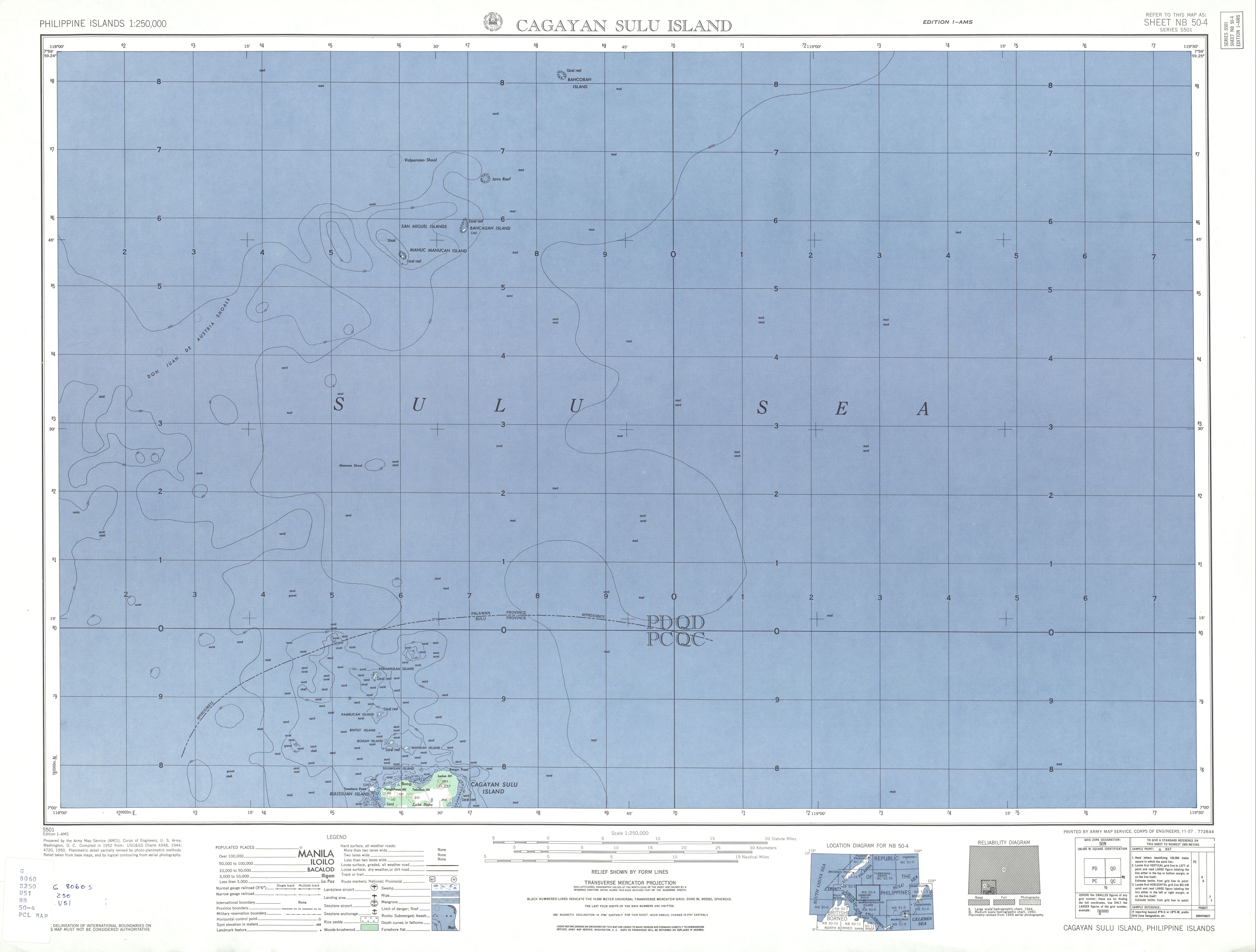
Cagayan de Tawi-Tawi ist der Name einer Insel der Provinz Tawi-Tawi auf den Philippinen. Vor der Einrichtung der Provinz Tawi-Tawi wurde die Insel Cagayan Sulu genannt (Namenszusatz nach der Sulusee). Der Namenszusatz ist erforderlich, um eine Verwechslung mit der Insel Cagayan (auch Cagayancillo, ebenfalls in der Sulusee, aber gut 400 km nordöstlich) auszuschließen. Die einheimischen Jama Mapun bezeichnen ihre Insel als Tanah Mapun, was übersetzt Land der Mapun bedeutet.
Die Insel liegt im südwestlichen Teil der Sulusee etwa 295 km vor der Nordküste der Provinzhauptstadt Bongao, 350 km westlich die Zamboanga Peninsula, 220 km nördlich liegt die Insel Palawan, 120 km südwestlich liegt Borneo und in 80 km Entfernung liegen die Turtle Islands. Die Insel hat eine Fläche von circa 172 km² und wird von der Stadtgemeinde Mapun verwaltet. Bei der Volkszählung 2007 wurden exakt 29801 Einwohner registriert.<ref>PSGC: <templatestyles src="Webarchiv/styles.css" />{{#if:20120901203842
| {{#ifeq: 20120901203842 | *
| {{#if: PSGC Interactive – Municipality: Mapun (Cagayan de Tawi-Tawi) | {{#invoke:WLink|getEscapedTitle|PSGC Interactive – Municipality: Mapun (Cagayan de Tawi-Tawi)}} | {{#invoke:Webarchiv|getdomain|http://www.nscb.gov.ph/activestats/psgc/municipality.asp?muncode=157003000®code=15&provcode=70}} }} (Archivversionen)
| {{#iferror: {{#time: j. F Y|20120901203842}}
| {{#if: || }}Der Wert des Parameters {{#if: wayback | wayback | Datum }} muss ein gültiger Zeitstempel der Form YYYYMMDDHHMMSS sein!
| {{#if: PSGC Interactive – Municipality: Mapun (Cagayan de Tawi-Tawi) | {{#invoke:WLink|getEscapedTitle|PSGC Interactive – Municipality: Mapun (Cagayan de Tawi-Tawi)}} | {{#invoke:Webarchiv|getdomain|http://www.nscb.gov.ph/activestats/psgc/municipality.asp?muncode=157003000®code=15&provcode=70}} }} {{#ifeq: | [] | [ | ( }}{{#if: {{#if: | {{{archiv-bot}}} | }} | des Vorlage:Referrer }} vom {{#time: j. F Y|20120901203842}} im Internet Archive{{#if: | ; }}{{#ifeq: | [] | ] | ) }}
}}
}}
| {{#if:
| {{#iferror: {{#time: j. F Y|{{{webciteID}}}}}
| {{#switch: {{#invoke:Str|len|{{{webciteID}}}}}
| 16= {{#if: PSGC Interactive – Municipality: Mapun (Cagayan de Tawi-Tawi) | {{#invoke:WLink|getEscapedTitle|PSGC Interactive – Municipality: Mapun (Cagayan de Tawi-Tawi)}} | {{#invoke:Webarchiv|getdomain|http://www.nscb.gov.ph/activestats/psgc/municipality.asp?muncode=157003000®code=15&provcode=70}} }} {{#ifeq: | [] | [ | ( }}{{#if: {{#if: | {{{archiv-bot}}} | }} | des Vorlage:Referrer }} vom {{#time: j. F Y| 19700101000000 + {{#expr: floor {{#expr: {{#invoke:Str|sub|{{{webciteID}}}|1|10}}/86400}} }} days}} auf WebCite{{#if: | ; }}{{#ifeq: | [] | ] | ) }}
| 9 = {{#if: PSGC Interactive – Municipality: Mapun (Cagayan de Tawi-Tawi) | {{#invoke:WLink|getEscapedTitle|PSGC Interactive – Municipality: Mapun (Cagayan de Tawi-Tawi)}} | {{#invoke:Webarchiv|getdomain|http://www.nscb.gov.ph/activestats/psgc/municipality.asp?muncode=157003000®code=15&provcode=70}} }} {{#ifeq: | [] | [ | ( }}{{#if: {{#if: | {{{archiv-bot}}} | }} | des Vorlage:Referrer}} vom {{#time: j. F Y| 19700101000000 + {{#expr: floor {{#expr: {{#invoke:Str|sub|{{#invoke:Expr|base62|{{{webciteID}}}}}|1|10}}/86400}} }} days}} auf WebCite{{#if: | ; }}{{#ifeq: | [] | ] | ) }}
| #default= Der Wert des Parameters {{#if: webciteID | webciteID | ID }} muss entweder ein Zeitstempel der Form YYYYMMDDHHMMSS oder ein Schüsselwert mit 9 Zeichen oder eine 16-stellige Zahl sein!{{#if: || }}
}}
| c|{{{webciteID}}}}} {{#if: PSGC Interactive – Municipality: Mapun (Cagayan de Tawi-Tawi) | {{#invoke:WLink|getEscapedTitle|PSGC Interactive – Municipality: Mapun (Cagayan de Tawi-Tawi)}} | {{#invoke:Webarchiv|getdomain|http://www.nscb.gov.ph/activestats/psgc/municipality.asp?muncode=157003000®code=15&provcode=70}} }} ({{#if: {{#if: | {{{archiv-bot}}} | }} | des Vorlage:Referrer}} vom {{#time: j. F Y|{{{webciteID}}}}} auf WebCite{{#if: | ; }}{{#ifeq: | [] | ] | ) }}
}}
| {{#if:
| Vorlage:Webarchiv/Today
| {{#if:
| Vorlage:Webarchiv/Generisch
| {{#if: PSGC Interactive – Municipality: Mapun (Cagayan de Tawi-Tawi) | {{#invoke:WLink|getEscapedTitle|PSGC Interactive – Municipality: Mapun (Cagayan de Tawi-Tawi)}} | {{#invoke:Webarchiv|getdomain|http://www.nscb.gov.ph/activestats/psgc/municipality.asp?muncode=157003000®code=15&provcode=70}} }}
}}}}}}}}{{#if:
| Vorlage:Webarchiv/archiv-bot
}}{{#invoke:TemplatePar|check
|all = url=
|opt = text= wayback= webciteID= archive-is= archive-today= archiv-url= archiv-datum= ()= archiv-bot= format= original=
|cat = Wikipedia:Vorlagenfehler/Vorlage:Webarchiv
|errNS = 0
|template = Vorlage:Webarchiv
|format = *
|preview = 1
}}{{#ifexpr: {{#if:20120901203842|1|0}}{{#if:|+1}}{{#if:|+1}}{{#if:|+1}}{{#if:|+1}} <> 1
| {{#if: || }}{{#invoke:TemplUtl|failure| Fehler bei Vorlage:Webarchiv: Genau einer der Parameter 'wayback', 'webciteID', 'archive-today', 'archive-is' oder 'archiv-url' muss angegeben werden.|1}}
}}{{#if:
| {{#switch: {{#invoke:Webarchiv|getdomain|{{{archiv-url}}}}}
| web.archive.org =
{{#if: || }}{{#invoke:TemplUtl|failure| Fehler bei Vorlage:Webarchiv: Im Parameter 'archiv-url' wurde URL von Internet Archive erkannt, bitte Parameter 'wayback' benutzen.|1}}
| webcitation.org =
{{#if: || }}{{#invoke:TemplUtl|failure| Fehler bei Vorlage:Webarchiv: Im Parameter 'archiv-url' wurde URL von WebCite erkannt, bitte Parameter 'webciteID' benutzen.|1}}
| archive.today |archive.is |archive.ph |archive.fo |archive.li |archive.md |archive.vn =
{{#if: || }}{{#invoke:TemplUtl|failure| Fehler bei Vorlage:Webarchiv: Im Parameter 'archiv-url' wurde URL von archive.today erkannt, bitte Parameter 'archive-today' benutzen.|1}}
}}{{#if:
| {{#iferror: {{#iferror:{{#invoke:Vorlage:FormatDate|Execute}}|}}
| {{#if: || }}{{#invoke:TemplUtl|failure| Fehler bei Vorlage:Webarchiv: Der Wert des Parameter 'archiv-datum' ist ungültig oder hat ein ungültiges Format.|1}}
| }}
| {{#if: || }}{{#invoke:TemplUtl|failure| Fehler bei Vorlage:Webarchiv: Der Pflichtparameter 'archiv-datum' wurde nicht angegeben.|1}}
}}
| {{#if:
| {{#if: || }}{{#invoke:TemplUtl|failure| Fehler bei Vorlage:Webarchiv: Der Parameter 'archiv-datum' ist nur in Verbindung mit 'archiv-url' angebbar.|1}}
}}
}}{{#if:{{#invoke:URLutil|isHostPathResource|http://www.nscb.gov.ph/activestats/psgc/municipality.asp?muncode=157003000®code=15&provcode=70}}
|| {{#if: || }}
}}{{#if: PSGC Interactive – Municipality: Mapun (Cagayan de Tawi-Tawi)
| {{#if: {{#invoke:WLink|isBracketedLink|PSGC Interactive – Municipality: Mapun (Cagayan de Tawi-Tawi)}}
| {{#if: || }}
}}
| {{#if: || }}
}}{{#switch:
|addlarchives|addlpages= {{#if: || }}{{#if: 1 |}}{{#invoke:TemplUtl|failure| Fehler bei Vorlage:Webarchiv: enWP-Wert im Parameter 'format'.|1}}
}}{{#ifeq: {{#invoke:Str|find|http://www.nscb.gov.ph/activestats/psgc/municipality.asp?muncode=157003000®code=15&provcode=70%7Carchiv}} |-1
|| {{#ifeq: {{#invoke:Str|find|{{#invoke:Str|cropleft|http://www.nscb.gov.ph/activestats/psgc/municipality.asp?muncode=157003000®code=15&provcode=70%7C4}}%7Chttp}} |-1
|| {{#switch: {{#invoke:Webarchiv|getdomain|http://www.nscb.gov.ph/activestats/psgc/municipality.asp?muncode=157003000®code=15&provcode=70 }}
| abendblatt.de | daserste.ndr.de | inarchive.com | webcitation.org =
| #default = {{#if: || }}{{#if: 1 |}}{{#invoke:TemplUtl|failure| Fehler bei Vorlage:Webarchiv: Archiv-URL im Parameter 'url' anstatt URL der Originalquelle. Entferne den vor der Original-URL stehenden Mementobestandteil und setze den Archivierungszeitstempel in den Parameter 'wayback', 'webciteID', 'archive.today' oder 'archive-is' ein, sofern nicht bereits befüllt.|1}}
}}
}}
}} (englisch)</ref>
Die Insel hat eine herzförmige Form, mit einer weitausladenden Halbinsel im südlichen Teil. Der 14,6 km langen und 9,4 km breiten Insel sind zahlreiche Inseln, Korallenriffe und Seegraswiesen vorgelagert (zum Barangay Boki gehörig). 12 Kilometer südsüdwestlich liegen die Muligi Islands, bestehend aus Muligi Diki und Muligi Mihi. Nur 300 Meter vor der Westspitze liegt Bulissuan Island (zum Barangay Sikub gehörig). Die nördlichste Insel ist Keenapusan 15,5 km nordnordwestlich der Hauptinsel (zum Barangay Umus Mataha gehörig). Dazwischen liegen die Inseln Pamelican, Bintut, Bohan, Bisu Bintut, Bisu Bohan, Mandah, sowie unmittelbar vor der Küste Silumisan und Lapunlapun.
Durch ihre abgeschiedene Lage hat sich bisher kein Tourismus entwickeln können. Die Topographie der Insel ist sehr flachhügelig, die höchste Erhebung ist der Mount Ledan.<ref>Topographische Karte 1:250.000, Kartenblatt NB 50-4</ref> Er erhebt sich 329 Meter über den Meeresspiegel. Der Pflanzenwuchs der Insel besteht aus einer dichten tropischen, aber sehr niedrigen Vegetation, im Inselinneren finden sich auch kleinere landwirtschaftlich genutzte Flächen. Es finden sich in der Nähe der Südküste der Lake Danao (24 ha) und der Lake Singuang (29 ha). Beides sind Vulkankraterseen, die über Süßwasserquellen gespeist werden. In ihrer Nähe liegt die Jurata Bay, sie bildet einen natürlichen Hafen und entstand durch einen Vulkanausbruch. Sie wurde während des Zweiten Weltkrieges als Hafen von der US Navy genutzt. Der Lake Sapah (6 ha) liegt im Inselzentrum, er ist ein flacher See der nur über Regenfälle gespeist wird.
Fährverbindungen zur Insel bestehen keine, es müssen Boote gemietet werden. Die kürzeste Anreise ist von Brooke’s Point (17 Stunden), von Bangao ca. 23 Stunden möglich. Von Zamboanga City dauert die Überfahrt ca. 27 Stunden.<ref>Webseite der Gemeinde Mapun</ref>
Einzelnachweise
<references/>
- Seiten mit nicht-numerischen formatnum-Argumenten
- Wikipedia:Koordinaten-Parameterfehler
- Unbewohnte Insel
- Wikipedia:Vorlagenfehler/Vorlage:Infobox Insel/Pflichtparameter fehlt
- Wikipedia:Vorlagenfehler/Vorlage:Webarchiv
- Wikipedia:Vorlagenfehler/Vorlage:Webarchiv/Archiv-URL
- Wikipedia:Vorlagenfehler/Parameter:URL
- Wikipedia:Vorlagenfehler/Parameter:Linktext
- Wikipedia:Vorlagenfehler/Vorlage:Webarchiv/Linktext fehlt
- Insel (Philippinen)
- Insel (Asien)
- Tawi-Tawi
- Insel (Sulusee)