Lusancay-Inseln
| {{#if:|{{{Name}}}|{{#invoke:WLink|getArticleBase}}}} | |||||||||||||||||||||||||||||||||||||||||||||||||||||||||||||||||||||||||||||||||||||||||||||||||||||||||||||||||||||||||||||||||||||||||||||||||||||||||||||||||||||||||||||||||||||||||||||||||||||||||||||||||||||||||||||||||||||||||||||||||||||||||||||||||||||||||||||||||||||||||||||||||||||||||||||||||||||||||||||||||
|---|---|---|---|---|---|---|---|---|---|---|---|---|---|---|---|---|---|---|---|---|---|---|---|---|---|---|---|---|---|---|---|---|---|---|---|---|---|---|---|---|---|---|---|---|---|---|---|---|---|---|---|---|---|---|---|---|---|---|---|---|---|---|---|---|---|---|---|---|---|---|---|---|---|---|---|---|---|---|---|---|---|---|---|---|---|---|---|---|---|---|---|---|---|---|---|---|---|---|---|---|---|---|---|---|---|---|---|---|---|---|---|---|---|---|---|---|---|---|---|---|---|---|---|---|---|---|---|---|---|---|---|---|---|---|---|---|---|---|---|---|---|---|---|---|---|---|---|---|---|---|---|---|---|---|---|---|---|---|---|---|---|---|---|---|---|---|---|---|---|---|---|---|---|---|---|---|---|---|---|---|---|---|---|---|---|---|---|---|---|---|---|---|---|---|---|---|---|---|---|---|---|---|---|---|---|---|---|---|---|---|---|---|---|---|---|---|---|---|---|---|---|---|---|---|---|---|---|---|---|---|---|---|---|---|---|---|---|---|---|---|---|---|---|---|---|---|---|---|---|---|---|---|---|---|---|---|---|---|---|---|---|---|---|---|---|---|---|---|---|---|---|---|---|---|---|---|---|---|---|---|---|---|---|---|---|---|---|---|---|---|---|---|---|---|---|---|---|---|---|---|---|---|---|---|---|---|---|---|---|---|---|---|---|---|---|---|---|---|---|---|---|
}} | |||||||||||||||||||||||||||||||||||||||||||||||||||||||||||||||||||||||||||||||||||||||||||||||||||||||||||||||||||||||||||||||||||||||||||||||||||||||||||||||||||||||||||||||||||||||||||||||||||||||||||||||||||||||||||||||||||||||||||||||||||||||||||||||||||||||||||||||||||||||||||||||||||||||||||||||||||||||||||||||||
| Gewässer | {{#ifexist: Salomonensee|[[Salomonensee]]|Salomonensee}} | {{#if:2229765 | colspan="2" | Pflichtparameter GEWAESSER fehlt }}
}} | ||||||||||||||||||||||||||||||||||||||||||||||||||||||||||||||||||||||||||||||||||||||||||||||||||||||||||||||||||||||||||||||||||||||||||||||||||||||||||||||||||||||||||||||||||||||||||||||||||||||||||||||||||||||||||||||||||||||||||||||||||||||||||||||||||||||||||||||||||||||||||||||||||||||||||||||||||||||||||||||
| Archipel | {{#ifexist: Louisiade-Archipel|[[Louisiade-Archipel]]|Louisiade-Archipel}}
}} | ||||||||||||||||||||||||||||||||||||||||||||||||||||||||||||||||||||||||||||||||||||||||||||||||||||||||||||||||||||||||||||||||||||||||||||||||||||||||||||||||||||||||||||||||||||||||||||||||||||||||||||||||||||||||||||||||||||||||||||||||||||||||||||||||||||||||||||||||||||||||||||||||||||||||||||||||||||||||||||||||
| 1|1}}|{{#switch:{{Info ISO-3166-2:{{#titleparts:PG-MBA|1|1}}|level}} | 1|2={{Info ISO-3166-2:{{#titleparts:PG-MBA|1|1}}|{{#switch:top | 1|1}}|level}} | adm2nd=2 | adm1st=1 | country=0 | #default=top
}} }} |
#default={{#switch: top | continent = | level = | maxlevel = | acronym = | top = ?? | upper = | admtype = | admtypelink = | admname = | lemma = | 0 = | 1 = | 2 = | map = Erde | flag = Flag of None.svg
}} }}}} |
LI|CH|GB={{#switch:{{#if:{{#titleparts:PG-MBA|1|2}}|{{#switch:{{Info ISO-3166-2:{{#titleparts:PG-MBA|1|2}}|level}} | 1|2={{Info ISO-3166-2:{{#titleparts:PG-MBA|1|2}}|{{#switch:top | 1|2}}|level}} | adm2nd=2 | adm1st=1 | country=0 | #default=top
}} }} |
#default={{#switch: top | continent = | level = | maxlevel = | acronym = | top = ?? | upper = | admtype = | admtypelink = | admname = | lemma = | 0 = | 1 = | 2 = | map = Erde | flag = Flag of None.svg
}} }}}} |
LI|CH|GB={{#switch:{{#if:{{#titleparts:PG-MBA|1|3}}|{{#switch:{{Info ISO-3166-2:{{#titleparts:PG-MBA|1|3}}|level}} | 1|2={{Info ISO-3166-2:{{#titleparts:PG-MBA|1|3}}|{{#switch:top | 1|3}}|level}} | adm2nd=2 | adm1st=1 | country=0 | #default=top
}} }} |
#default={{#switch: top | continent = | level = | maxlevel = | acronym = | top = ?? | upper = | admtype = | admtypelink = | admname = | lemma = | 0 = | 1 = | 2 = | map = Erde | flag = Flag of None.svg
}} }}}} |
CH|GB={{#switch:{{#if:{{#titleparts:PG-MBA|1|4}}|{{#switch:{{Info ISO-3166-2:{{#titleparts:PG-MBA|1|4}}|level}} | 1|2={{Info ISO-3166-2:{{#titleparts:PG-MBA|1|4}}|{{#switch:top | 1|4}}|level}} | adm2nd=2 | adm1st=1 | country=0 | #default=top
}} }} |
#default={{#switch: top | continent = | level = | maxlevel = | acronym = | top = ?? | upper = | admtype = | admtypelink = | admname = | lemma = | 0 = | 1 = | 2 = | map = Erde | flag = Flag of None.svg
}} }}}}||LI|CH|GB=|#default=DMS/}} |
#default=DMS/}} | #default=DMS/}} | #default=DMS/}}{{#switch:CH | 1|1}}|{{#switch:{{Info ISO-3166-2:{{#titleparts:PG-MBA|1|1}}|level}} | 1|2={{Info ISO-3166-2:{{#titleparts:PG-MBA|1|1}}|{{#switch:top | 1|1}}|level}} | adm2nd=2 | adm1st=1 | country=0 | #default=top
}} }} |
#default={{#switch: top | continent = | level = | maxlevel = | acronym = | top = ?? | upper = | admtype = | admtypelink = | admname = | lemma = | 0 = | 1 = | 2 = | map = Erde | flag = Flag of None.svg
}} }}}} |
1|2}}|{{#switch:{{Info ISO-3166-2:{{#titleparts:PG-MBA|1|2}}|level}} | 1|2={{Info ISO-3166-2:{{#titleparts:PG-MBA|1|2}}|{{#switch:top | 1|2}}|level}} | adm2nd=2 | adm1st=1 | country=0 | #default=top
}} }} |
#default={{#switch: top | continent = | level = | maxlevel = | acronym = | top = ?? | upper = | admtype = | admtypelink = | admname = | lemma = | 0 = | 1 = | 2 = | map = Erde | flag = Flag of None.svg
}} }}}} |
1|3}}|{{#switch:{{Info ISO-3166-2:{{#titleparts:PG-MBA|1|3}}|level}} | 1|2={{Info ISO-3166-2:{{#titleparts:PG-MBA|1|3}}|{{#switch:top | 1|3}}|level}} | adm2nd=2 | adm1st=1 | country=0 | #default=top
}} }} |
#default={{#switch: top | continent = | level = | maxlevel = | acronym = | top = ?? | upper = | admtype = | admtypelink = | admname = | lemma = | 0 = | 1 = | 2 = | map = Erde | flag = Flag of None.svg
}} }}}} |
1|4}}|{{#switch:{{Info ISO-3166-2:{{#titleparts:PG-MBA|1|4}}|level}} | 1|2={{Info ISO-3166-2:{{#titleparts:PG-MBA|1|4}}|{{#switch:top | 1|4}}|level}} | adm2nd=2 | adm1st=1 | country=0 | #default=top
}} }} |
#default={{#switch: top | continent = | level = | maxlevel = | acronym = | top = ?? | upper = | admtype = | admtypelink = | admname = | lemma = | 0 = | 1 = | 2 = | map = Erde | flag = Flag of None.svg
}} }}}}=CH1903/CH1903 |
#default={{#switch:LI | 1|1}}|{{#switch:{{Info ISO-3166-2:{{#titleparts:PG-MBA|1|1}}|level}} | 1|2={{Info ISO-3166-2:{{#titleparts:PG-MBA|1|1}}|{{#switch:top | 1|1}}|level}} | adm2nd=2 | adm1st=1 | country=0 | #default=top
}} }} |
#default={{#switch: top | continent = | level = | maxlevel = | acronym = | top = ?? | upper = | admtype = | admtypelink = | admname = | lemma = | 0 = | 1 = | 2 = | map = Erde | flag = Flag of None.svg
}} }}}} |
1|2}}|{{#switch:{{Info ISO-3166-2:{{#titleparts:PG-MBA|1|2}}|level}} | 1|2={{Info ISO-3166-2:{{#titleparts:PG-MBA|1|2}}|{{#switch:top | 1|2}}|level}} | adm2nd=2 | adm1st=1 | country=0 | #default=top
}} }} |
#default={{#switch: top | continent = | level = | maxlevel = | acronym = | top = ?? | upper = | admtype = | admtypelink = | admname = | lemma = | 0 = | 1 = | 2 = | map = Erde | flag = Flag of None.svg
}} }}}} |
1|3}}|{{#switch:{{Info ISO-3166-2:{{#titleparts:PG-MBA|1|3}}|level}} | 1|2={{Info ISO-3166-2:{{#titleparts:PG-MBA|1|3}}|{{#switch:top | 1|3}}|level}} | adm2nd=2 | adm1st=1 | country=0 | #default=top
}} }} |
#default={{#switch: top | continent = | level = | maxlevel = | acronym = | top = ?? | upper = | admtype = | admtypelink = | admname = | lemma = | 0 = | 1 = | 2 = | map = Erde | flag = Flag of None.svg
}} }}}} |
1|4}}|{{#switch:{{Info ISO-3166-2:{{#titleparts:PG-MBA|1|4}}|level}} | 1|2={{Info ISO-3166-2:{{#titleparts:PG-MBA|1|4}}|{{#switch:top | 1|4}}|level}} | adm2nd=2 | adm1st=1 | country=0 | #default=top
}} }} |
#default={{#switch: top | continent = | level = | maxlevel = | acronym = | top = ?? | upper = | admtype = | admtypelink = | admname = | lemma = | 0 = | 1 = | 2 = | map = Erde | flag = Flag of None.svg
}} }}}}=CH1903/CH1903 |
#default=DMS/DMS
}}}} |
DMS/CH1903/CH1903={{#if:Geographische Lage|Geographische Lage|Koordinaten}}, (CH) | CH1903/CH1903={{#if:Geographische Lage|Geographische Lage|Koordinaten}} | OSGB36/OSGB36=Ordnance Survey GB | UTM=UTM-Koordinaten | #default={{#if:Geographische Lage|Geographische Lage|Koordinaten}}
}} |
y|Simple|Complex}}|NS=8/30/0/S|EW=150/30/0/E|type=isle|region=PG-MBA|globe=|dim=|elevation=|pop=290|lw=|name={{#invoke:Coordinates/kml|kmlTitle|1={{#if: |{{{Name}}}|{{#invoke:WLink|getArticleBase}}}}}}|article={{#if: | text=/|sortkey=|tooltip=|tooltipformat=|map=|mapsize=|maplevel=|maptype=|maplabel=|maplayer=|mapcaption=}}{{#if:|{{#switch:5 | 1 = Gradzahl-Fehler: {{#iferror:{{{1}}} | NS: {{{1}}} |
}} {{#iferror:
|
EW: |
}}{{#switch:0
|
6|14=
}} |
2 = nicht im Bereich von {{{1}}}{{#switch:0 | 6|14=
}} |
3 = {{#switch: {{{type}}} | state|adm1st|adm2nd|city|isle|airport|mountain|waterbody|forest|landmark= | example={{#if: | falscher Wert ›example‹ im Artikelnamensraum
}} |
kein Wert | falscher Wert ›{{{type}}}‹
}} in type-Parameter{{#switch:0 |
6|14=
}}
}} {{#if: {{{rg}}}
|
region-Parameter fehlt{{#if: |
}}
}} {{#iferror: {{{elevation}}}
|
{{{elevation}}}{{#switch:0 | 6|14=
}} |
}} {{#iferror: {{{pop}}}
|
{{{pop}}}{{#switch:0 | 6|14=
}} |
}} |
, 2:}}{{#if:|, 3:}}{{#if:|, 4:}} {{#if:|usw.}}{{#switch:0 | 6|14=
}} |
8 = Parameter name fehlt in Fließtextkoordinate{{#switch:0 | 6|14=
}} |
10= | #default=coordinates error
}}}} | |||||
| [[Datei:|300px|zentriert|alt=|Karte von {{#if: | Lusancay-Inseln}}]] | {{#switch: |none|keine|-= | colspan="2" style="text-align:center; padding:0;" |
{{ Positionskarte {{#if: ||ISO 3166-2 }}
|
1={{#if: | {{#ifeq:/PG-MBA | 1|{{#expr:1+1}}}} | 1|{{#expr:1+1}}}}
}} }} |
label= Lusancay-Inseln | {{{Name}}}|{{#invoke:WLink|getArticleBase}}}} | position=none | lat=8/30/0/S | long=150/30/0/E | pop=290 |elevation= |region=PG-MBA | dim= | width=300 | border=none | caption= | marksize=20 | maptype=relief
}} | ||||||||||||||||||||||||||||||||||||||||||||||||||||||||||||||||||||||||||||||||||||||||||||||||||||||||||||||||||||||||||||||||||||||||||||||||||||||||||||||||||||||||||||||||||||||||||||||||||||||||||||||||||||||||||||||||||||||||||||||||||||||||||||||||||||||||||||||||||||||||||||||||||||||||||||||
| Anzahl der Inseln | 17 | {{#if:2229765 | colspan="2" | Pflichtparameter INSELN fehlt }}
}} | ||||||||||||||||||||||||||||||||||||||||||||||||||||||||||||||||||||||||||||||||||||||||||||||||||||||||||||||||||||||||||||||||||||||||||||||||||||||||||||||||||||||||||||||||||||||||||||||||||||||||||||||||||||||||||||||||||||||||||||||||||||||||||||||||||||||||||||||||||||||||||||||||||||||||||||||||||||||||||||||
| Hauptinsel | Kawa Island
}} | ||||||||||||||||||||||||||||||||||||||||||||||||||||||||||||||||||||||||||||||||||||||||||||||||||||||||||||||||||||||||||||||||||||||||||||||||||||||||||||||||||||||||||||||||||||||||||||||||||||||||||||||||||||||||||||||||||||||||||||||||||||||||||||||||||||||||||||||||||||||||||||||||||||||||||||||||||||||||||||||||
| Gesamte Landfläche | Masz}} | {{#if:2229765 | colspan="2" | Pflichtparameter FLAECHE fehlt }}
}} | ||||||||||||||||||||||||||||||||||||||||||||||||||||||||||||||||||||||||||||||||||||||||||||||||||||||||||||||||||||||||||||||||||||||||||||||||||||||||||||||||||||||||||||||||||||||||||||||||||||||||||||||||||||||||||||||||||||||||||||||||||||||||||||||||||||||||||||||||||||||||||||||||||||||||||||||||||||||||||||||
| Einwohner | 0|unbewohnt{{#ifeq: | |}} |Vorlage:FormatNumDef {{#if:|({{{ZENSUS}}})}} }}
}} | ||||||||||||||||||||||||||||||||||||||||||||||||||||||||||||||||||||||||||||||||||||||||||||||||||||||||||||||||||||||||||||||||||||||||||||||||||||||||||||||||||||||||||||||||||||||||||||||||||||||||||||||||||||||||||||||||||||||||||||||||||||||||||||||||||||||||||||||||||||||||||||||||||||||||||||||||||||||||||||||||
| [[Datei:|300px|zentriert|alt=|]]
}} | |||||||||||||||||||||||||||||||||||||||||||||||||||||||||||||||||||||||||||||||||||||||||||||||||||||||||||||||||||||||||||||||||||||||||||||||||||||||||||||||||||||||||||||||||||||||||||||||||||||||||||||||||||||||||||||||||||||||||||||||||||||||||||||||||||||||||||||||||||||||||||||||||||||||||||||||||||||||||||||||||
{{#if: 8/30/0/S |{{#if: PG-MBA||
}} {{#switch: |none|keine|-=
}}
}}{{#if: || {{#if: Salomonensee||}} }}{{#if: || {{#if: 3.58||}} }}{{#if: || {{#if: 17||}} }} 
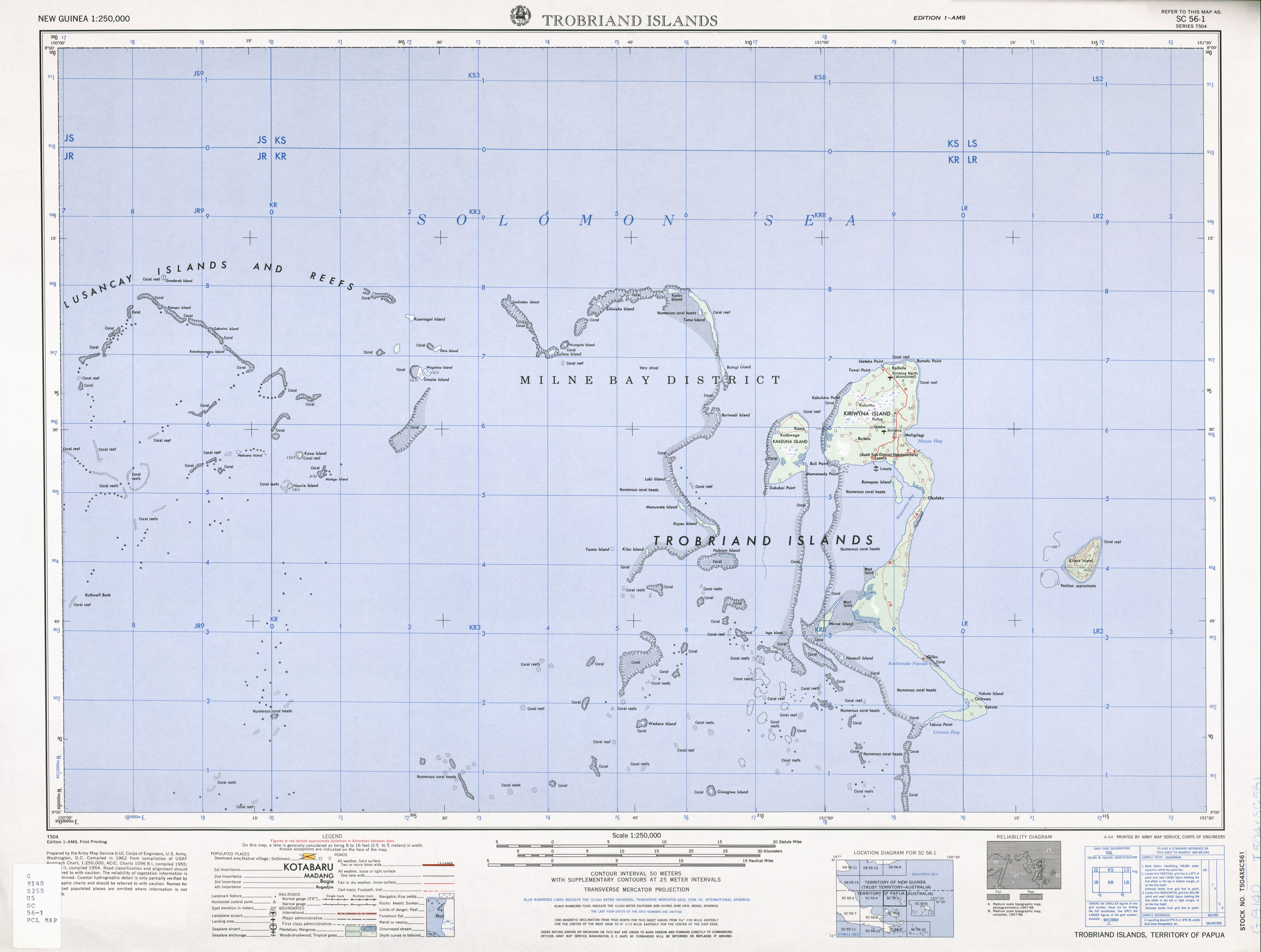
Die Lusancay-Inseln sind eine Inselgruppe mit etwa 17 Inseln in der Salomonensee. Verwaltungsmäßig gehören sie zur Kiriwina Rural LLG (Local Level Government) Area des Distrikts Kiriwina-Goodenough der Provinz Milne Bay im südöstlichen Bereich von Papua-Neuguinea.
Geographie
Die Inseln befinden sich im Westen der Trobriand-Inseln. Die Distanz der östlichsten Insel Silipwaka liegt nur 10,6 km westlich von Kadai Island im nordwestlichen Bereich der Trobriand-Inseln. Sie liegen außerdem rund 65 Kilometer nördlich der D’Entrecasteaux-Inseln. Mit den Star-Riffen im Westen umfassen die Lusancay-Inseln ein großes Gebiet von seichtem Wasser, Riffen und Inseln, das sich über 100 km von Osten nach Westen und genauso weit von Norden nach Süden erstreckt.<ref><templatestyles src="Webarchiv/styles.css" />{{#if:20120926000701
| {{#ifeq: 20120926000701 | *
| {{#if: Oceandots: Lusancay Islands and Reefs | {{#invoke:WLink|getEscapedTitle|Oceandots: Lusancay Islands and Reefs}} | {{#invoke:Webarchiv|getdomain|http://www.oceandots.com/pacific/png/lusancay.php}} }} (Archivversionen)
| {{#iferror: {{#time: j. F Y|20120926000701}}
| {{#if: || }}Der Wert des Parameters {{#if: wayback | wayback | Datum }} muss ein gültiger Zeitstempel der Form YYYYMMDDHHMMSS sein!
| {{#if: Oceandots: Lusancay Islands and Reefs | {{#invoke:WLink|getEscapedTitle|Oceandots: Lusancay Islands and Reefs}} | {{#invoke:Webarchiv|getdomain|http://www.oceandots.com/pacific/png/lusancay.php}} }} {{#ifeq: | [] | [ | ( }}{{#if: {{#if: | {{{archiv-bot}}} | }} | des Vorlage:Referrer }} vom {{#time: j. F Y|20120926000701}} im Internet Archive{{#if: | ; }}{{#ifeq: | [] | ] | ) }}
}}
}}
| {{#if:
| {{#iferror: {{#time: j. F Y|{{{webciteID}}}}}
| {{#switch: {{#invoke:Str|len|{{{webciteID}}}}}
| 16= {{#if: Oceandots: Lusancay Islands and Reefs | {{#invoke:WLink|getEscapedTitle|Oceandots: Lusancay Islands and Reefs}} | {{#invoke:Webarchiv|getdomain|http://www.oceandots.com/pacific/png/lusancay.php}} }} {{#ifeq: | [] | [ | ( }}{{#if: {{#if: | {{{archiv-bot}}} | }} | des Vorlage:Referrer }} vom {{#time: j. F Y| 19700101000000 + {{#expr: floor {{#expr: {{#invoke:Str|sub|{{{webciteID}}}|1|10}}/86400}} }} days}} auf WebCite{{#if: | ; }}{{#ifeq: | [] | ] | ) }}
| 9 = {{#if: Oceandots: Lusancay Islands and Reefs | {{#invoke:WLink|getEscapedTitle|Oceandots: Lusancay Islands and Reefs}} | {{#invoke:Webarchiv|getdomain|http://www.oceandots.com/pacific/png/lusancay.php}} }} {{#ifeq: | [] | [ | ( }}{{#if: {{#if: | {{{archiv-bot}}} | }} | des Vorlage:Referrer}} vom {{#time: j. F Y| 19700101000000 + {{#expr: floor {{#expr: {{#invoke:Str|sub|{{#invoke:Expr|base62|{{{webciteID}}}}}|1|10}}/86400}} }} days}} auf WebCite{{#if: | ; }}{{#ifeq: | [] | ] | ) }}
| #default= Der Wert des Parameters {{#if: webciteID | webciteID | ID }} muss entweder ein Zeitstempel der Form YYYYMMDDHHMMSS oder ein Schüsselwert mit 9 Zeichen oder eine 16-stellige Zahl sein!{{#if: || }}
}}
| c|{{{webciteID}}}}} {{#if: Oceandots: Lusancay Islands and Reefs | {{#invoke:WLink|getEscapedTitle|Oceandots: Lusancay Islands and Reefs}} | {{#invoke:Webarchiv|getdomain|http://www.oceandots.com/pacific/png/lusancay.php}} }} ({{#if: {{#if: | {{{archiv-bot}}} | }} | des Vorlage:Referrer}} vom {{#time: j. F Y|{{{webciteID}}}}} auf WebCite{{#if: | ; }}{{#ifeq: | [] | ] | ) }}
}}
| {{#if:
| Vorlage:Webarchiv/Today
| {{#if:
| Vorlage:Webarchiv/Generisch
| {{#if: Oceandots: Lusancay Islands and Reefs | {{#invoke:WLink|getEscapedTitle|Oceandots: Lusancay Islands and Reefs}} | {{#invoke:Webarchiv|getdomain|http://www.oceandots.com/pacific/png/lusancay.php}} }}
}}}}}}}}{{#if:
| Vorlage:Webarchiv/archiv-bot
}}{{#invoke:TemplatePar|check
|all = url=
|opt = text= wayback= webciteID= archive-is= archive-today= archiv-url= archiv-datum= ()= archiv-bot= format= original=
|cat = Wikipedia:Vorlagenfehler/Vorlage:Webarchiv
|errNS = 0
|template = Vorlage:Webarchiv
|format = *
|preview = 1
}}{{#ifexpr: {{#if:20120926000701|1|0}}{{#if:|+1}}{{#if:|+1}}{{#if:|+1}}{{#if:|+1}} <> 1
| {{#if: || }}{{#invoke:TemplUtl|failure| Fehler bei Vorlage:Webarchiv: Genau einer der Parameter 'wayback', 'webciteID', 'archive-today', 'archive-is' oder 'archiv-url' muss angegeben werden.|1}}
}}{{#if:
| {{#switch: {{#invoke:Webarchiv|getdomain|{{{archiv-url}}}}}
| web.archive.org =
{{#if: || }}{{#invoke:TemplUtl|failure| Fehler bei Vorlage:Webarchiv: Im Parameter 'archiv-url' wurde URL von Internet Archive erkannt, bitte Parameter 'wayback' benutzen.|1}}
| webcitation.org =
{{#if: || }}{{#invoke:TemplUtl|failure| Fehler bei Vorlage:Webarchiv: Im Parameter 'archiv-url' wurde URL von WebCite erkannt, bitte Parameter 'webciteID' benutzen.|1}}
| archive.today |archive.is |archive.ph |archive.fo |archive.li |archive.md |archive.vn =
{{#if: || }}{{#invoke:TemplUtl|failure| Fehler bei Vorlage:Webarchiv: Im Parameter 'archiv-url' wurde URL von archive.today erkannt, bitte Parameter 'archive-today' benutzen.|1}}
}}{{#if:
| {{#iferror: {{#iferror:{{#invoke:Vorlage:FormatDate|Execute}}|}}
| {{#if: || }}{{#invoke:TemplUtl|failure| Fehler bei Vorlage:Webarchiv: Der Wert des Parameter 'archiv-datum' ist ungültig oder hat ein ungültiges Format.|1}}
| }}
| {{#if: || }}{{#invoke:TemplUtl|failure| Fehler bei Vorlage:Webarchiv: Der Pflichtparameter 'archiv-datum' wurde nicht angegeben.|1}}
}}
| {{#if:
| {{#if: || }}{{#invoke:TemplUtl|failure| Fehler bei Vorlage:Webarchiv: Der Parameter 'archiv-datum' ist nur in Verbindung mit 'archiv-url' angebbar.|1}}
}}
}}{{#if:{{#invoke:URLutil|isHostPathResource|http://www.oceandots.com/pacific/png/lusancay.php}}
|| {{#if: || }}
}}{{#if: Oceandots: Lusancay Islands and Reefs
| {{#if: {{#invoke:WLink|isBracketedLink|Oceandots: Lusancay Islands and Reefs}}
| {{#if: || }}
}}
| {{#if: || }}
}}{{#switch:
|addlarchives|addlpages= {{#if: || }}{{#if: 1 |}}{{#invoke:TemplUtl|failure| Fehler bei Vorlage:Webarchiv: enWP-Wert im Parameter 'format'.|1}}
}}{{#ifeq: {{#invoke:Str|find|http://www.oceandots.com/pacific/png/lusancay.php%7Carchiv}} |-1
|| {{#ifeq: {{#invoke:Str|find|{{#invoke:Str|cropleft|http://www.oceandots.com/pacific/png/lusancay.php%7C4}}%7Chttp}} |-1
|| {{#switch: {{#invoke:Webarchiv|getdomain|http://www.oceandots.com/pacific/png/lusancay.php }}
| abendblatt.de | daserste.ndr.de | inarchive.com | webcitation.org =
| #default = {{#if: || }}{{#if: 1 |}}{{#invoke:TemplUtl|failure| Fehler bei Vorlage:Webarchiv: Archiv-URL im Parameter 'url' anstatt URL der Originalquelle. Entferne den vor der Original-URL stehenden Mementobestandteil und setze den Archivierungszeitstempel in den Parameter 'wayback', 'webciteID', 'archive.today' oder 'archive-is' ein, sofern nicht bereits befüllt.|1}}
}}
}}
}}</ref> Nur die Hauptinsel Kawa sowie die Insel Simsim (Konia) sind bewohnt, mit 165 bzw. 125 Einwohnern zur Volkszählung 2000. Die Hauptinsel Kawa Island ist die nach Fläche und Einwohnerzahl größte Insel. Früher war wahrscheinlich auch Kwaiyaluma bewohnt.<ref>Gunter Senft: The Trobriand Islanders' Way of Speaking. 2010. ISBN 978-3-11-022798-7, S. 132: In 1992 Tokunupei ... told me that Keli was a village on Kwaiyaluma Island, one of the Lusancay Islands. ({{#if: eLSqIMLzm8EC
| {{#if: {{#if: ||1}} {{#if: eLSqIMLzm8EC ||1}}
| <0|&pg={{#if:|RA{{{Band}}}-}}PA136|&pg=136}}{{#if:|&q=}}#v=onepage|{{#if:|&pg=|}}{{#if:|&q=}}}}{{#if:|q=%7B%7B%7BSuchbegriff%7D%7D%7D}}|{{#if:|q=%7B%7B%7BSuchbegriff%7D%7D%7D}}}} {{#if:|{{#invoke:WLink|getEscapedTitle|{{{Linktext}}}}}|eingeschränkte Vorschau}}{{#if:|| in der Google-Buchsuche}}{{#ifeq:|US|-USA}}{{#if: eLSqIMLzm8EC |{{#invoke: Vorlage:GoogleBook|fine |id=eLSqIMLzm8EC |errN=Parameter „BuchID“ hat falsche Länge |errC=Parameter „BuchID“ enthält ungültige Zeichen |errH=# in der „BuchID“ |errP=Parameterzuweisungen in der „BuchID“ |class=editoronly |cat={{#ifeq: 0 | 0 | Wikipedia:Vorlagenfehler/Vorlage:Google Buch}} |template= Vorlage:Google Buch}}
}}
| Es darf nur genau einer der beiden Parameter „Suchbegriff“ oder „BuchID“ ausgefüllt werden. Bitte beachte die in der Vorlage:Google Buch befindliche Dokumentation und prüfe die verwendeten Parameter.{{#ifeq: 0 | 0 | }}}}
| Es muss mindestens einer der beiden Parameter „Suchbegriff“ oder „BuchID“ ausgefüllt werden. Bitte beachte die in der Vorlage:Google Buch befindliche Dokumentation und prüfe die verwendeten Parameter.{{#ifeq: 0 | 0 | }}}}{{#invoke:TemplatePar|check
|all=
|opt= Suchbegriff= BuchID= Seite= Band= SeitenID= Hervorhebung= Linktext= Land= KeinText=
|cat= {{#ifeq: 0 | 0 | Wikipedia:Vorlagenfehler/Vorlage:Google Buch}}
|template= Vorlage:Google Buch
|format=
}}{{#if:|{{#if:{{#invoke:WLink|isBracketedLink|{{{Linktext}}}}}|}}}})</ref> Die östlichste der unter den Lusancay-Inseln genannten ist Silipuaka (Silipwaka).<ref>Pacific Islands Yearbook Band 11, 1972 (bei Google Books). In diesem Buch werden die südlichen Inseln Matagu, Nauria und Nukuana fälschlich mit der Laughland (Nada) Group aufgelistet, die östlich der Insel Woodlark liegt. Ansonsten ist in dieser Liste nur Kwaiyaluma nicht aufgeführt.</ref>
Inseln
Die 17 Inseln gliedern sich in eine östliche, eine südliche und in eine westliche Gruppe (mit Flächenangaben der PNAS extended islands database)<ref>PNAS extended islands database. Bei der Insel Kwaiyaluma wurde der Name vom NGA GEOnet Names Server ergänzt. Die fehlenden Angaben für die sehr kleinen Inseln Deia und Nukuana wurden vom Satellitenbild geschätzt.</ref>:
{{#ifeq: 0inline | 0
| {{#invoke:Vorlage:All Coordinates|f|section=|text=}}
| {{#switch: 0
|4
|5
|6
|7
|8
|9
|12
|13
|14
|15
|100
|101=
|#default=
}}: |§ion=%7B%7B%7Bsection%7D%7D%7D}} OSM {{#if: ||| WikiMap}}
}}}}
| Name | Koordinaten | Fläche km² |
Unter- gruppe | |||||||||||||||||||||||||||||||
|---|---|---|---|---|---|---|---|---|---|---|---|---|---|---|---|---|---|---|---|---|---|---|---|---|---|---|---|---|---|---|---|---|---|---|
| Silipwaka (Silipuaka) | {{Coordinate{{#ifeq:y|y|Simple|Complex}}|NS=-8.3260458941|EW=150.719180158|type=isle|region=PG-MBA|globe=|dim=|elevation=|pop=|lw=|name={{#invoke:Coordinates/kml|kmlTitle|1=Silipwaka}}|article=|text=DMS|sortkey=NS|tooltip=|tooltipformat=|map=|mapsize=|maplevel=|maptype=|maplabel=|maplayer=|mapcaption=}}{{#if:|{{#switch:5 | 1 = Gradzahl-Fehler: {{#iferror:{{{1}}} | NS: {{{1}}} |
}} {{#iferror:
|
EW: |
}}{{#switch:0
|
6|14=
}} |
2 = nicht im Bereich von {{{1}}}{{#switch:0 | 6|14=
}} |
3 = {{#switch: {{{type}}} | state|adm1st|adm2nd|city|isle|airport|mountain|waterbody|forest|landmark= | example={{#if: | falscher Wert ›example‹ im Artikelnamensraum
}} |
kein Wert | falscher Wert ›{{{type}}}‹
}} in type-Parameter{{#switch:0 |
6|14=
}}
}} {{#if: {{{rg}}}
|
region-Parameter fehlt{{#if: |
}}
}} {{#iferror: {{{elevation}}}
|
{{{elevation}}}{{#switch:0 | 6|14=
}} |
}} {{#iferror: {{{pop}}}
|
{{{pop}}}{{#switch:0 | 6|14=
}} |
}} |
, 2:}}{{#if:|, 3:}}{{#if:|, 4:}} {{#if:|usw.}}{{#switch:0 | 6|14=
}} |
8 = Parameter name fehlt in Fließtextkoordinate{{#switch:0 | 6|14=
}} |
10= | #default=coordinates error
}}}} ||align="right"|0,10 ||östliche | ||||
| Nuarguta | {{Coordinate{{#ifeq:y|y|Simple|Complex}}|NS=-8.3723284764|EW=150.663780037|type=isle|region=PG-MBA|globe=|dim=|elevation=|pop=|lw=|name={{#invoke:Coordinates/kml|kmlTitle|1=Nuarguta}}|article=|text=DMS|sortkey=NS|tooltip=|tooltipformat=|map=|mapsize=|maplevel=|maptype=|maplabel=|maplayer=|mapcaption=}}{{#if:|{{#switch:5 | 1 = Gradzahl-Fehler: {{#iferror:{{{1}}} | NS: {{{1}}} |
}} {{#iferror:
|
EW: |
}}{{#switch:0
|
6|14=
}} |
2 = nicht im Bereich von {{{1}}}{{#switch:0 | 6|14=
}} |
3 = {{#switch: {{{type}}} | state|adm1st|adm2nd|city|isle|airport|mountain|waterbody|forest|landmark= | example={{#if: | falscher Wert ›example‹ im Artikelnamensraum
}} |
kein Wert | falscher Wert ›{{{type}}}‹
}} in type-Parameter{{#switch:0 |
6|14=
}}
}} {{#if: {{{rg}}}
|
region-Parameter fehlt{{#if: |
}}
}} {{#iferror: {{{elevation}}}
|
{{{elevation}}}{{#switch:0 | 6|14=
}} |
}} {{#iferror: {{{pop}}}
|
{{{pop}}}{{#switch:0 | 6|14=
}} |
}} |
, 2:}}{{#if:|, 3:}}{{#if:|, 4:}} {{#if:|usw.}}{{#switch:0 | 6|14=
}} |
8 = Parameter name fehlt in Fließtextkoordinate{{#switch:0 | 6|14=
}} |
10= | #default=coordinates error
}}}} ||align="right"|0,08 ||östliche | ||||
| Lulima | {{Coordinate{{#ifeq:y|y|Simple|Complex}}|NS=-8.3916540029|EW=150.647339974|type=isle|region=PG-MBA|globe=|dim=|elevation=|pop=|lw=|name={{#invoke:Coordinates/kml|kmlTitle|1=Lulima}}|article=|text=DMS|sortkey=NS|tooltip=|tooltipformat=|map=|mapsize=|maplevel=|maptype=|maplabel=|maplayer=|mapcaption=}}{{#if:|{{#switch:5 | 1 = Gradzahl-Fehler: {{#iferror:{{{1}}} | NS: {{{1}}} |
}} {{#iferror:
|
EW: |
}}{{#switch:0
|
6|14=
}} |
2 = nicht im Bereich von {{{1}}}{{#switch:0 | 6|14=
}} |
3 = {{#switch: {{{type}}} | state|adm1st|adm2nd|city|isle|airport|mountain|waterbody|forest|landmark= | example={{#if: | falscher Wert ›example‹ im Artikelnamensraum
}} |
kein Wert | falscher Wert ›{{{type}}}‹
}} in type-Parameter{{#switch:0 |
6|14=
}}
}} {{#if: {{{rg}}}
|
region-Parameter fehlt{{#if: |
}}
}} {{#iferror: {{{elevation}}}
|
{{{elevation}}}{{#switch:0 | 6|14=
}} |
}} {{#iferror: {{{pop}}}
|
{{{pop}}}{{#switch:0 | 6|14=
}} |
}} |
, 2:}}{{#if:|, 3:}}{{#if:|, 4:}} {{#if:|usw.}}{{#switch:0 | 6|14=
}} |
8 = Parameter name fehlt in Fließtextkoordinate{{#switch:0 | 6|14=
}} |
10= | #default=coordinates error
}}}} ||align="right"|0,35 ||östliche | ||||
| Kwaiyaluma | {{Coordinate{{#ifeq:y|y|Simple|Complex}}|NS=-8.3509278616|EW=150.596342115|type=isle|region=PG-MBA|globe=|dim=|elevation=|pop=|lw=|name={{#invoke:Coordinates/kml|kmlTitle|1=Kwaiyaluma}}|article=|text=DMS|sortkey=NS|tooltip=|tooltipformat=|map=|mapsize=|maplevel=|maptype=|maplabel=|maplayer=|mapcaption=}}{{#if:|{{#switch:5 | 1 = Gradzahl-Fehler: {{#iferror:{{{1}}} | NS: {{{1}}} |
}} {{#iferror:
|
EW: |
}}{{#switch:0
|
6|14=
}} |
2 = nicht im Bereich von {{{1}}}{{#switch:0 | 6|14=
}} |
3 = {{#switch: {{{type}}} | state|adm1st|adm2nd|city|isle|airport|mountain|waterbody|forest|landmark= | example={{#if: | falscher Wert ›example‹ im Artikelnamensraum
}} |
kein Wert | falscher Wert ›{{{type}}}‹
}} in type-Parameter{{#switch:0 |
6|14=
}}
}} {{#if: {{{rg}}}
|
region-Parameter fehlt{{#if: |
}}
}} {{#iferror: {{{elevation}}}
|
{{{elevation}}}{{#switch:0 | 6|14=
}} |
}} {{#iferror: {{{pop}}}
|
{{{pop}}}{{#switch:0 | 6|14=
}} |
}} |
, 2:}}{{#if:|, 3:}}{{#if:|, 4:}} {{#if:|usw.}}{{#switch:0 | 6|14=
}} |
8 = Parameter name fehlt in Fließtextkoordinate{{#switch:0 | 6|14=
}} |
10= | #default=coordinates error
}}}} ||align="right"|0,11 ||östliche | ||||
| Simlindon | {{Coordinate{{#ifeq:y|y|Simple|Complex}}|NS=-8.3308072641|EW=150.580890856|type=isle|region=PG-MBA|globe=|dim=|elevation=|pop=|lw=|name={{#invoke:Coordinates/kml|kmlTitle|1=Simlindon}}|article=|text=DMS|sortkey=NS|tooltip=|tooltipformat=|map=|mapsize=|maplevel=|maptype=|maplabel=|maplayer=|mapcaption=}}{{#if:|{{#switch:5 | 1 = Gradzahl-Fehler: {{#iferror:{{{1}}} | NS: {{{1}}} |
}} {{#iferror:
|
EW: |
}}{{#switch:0
|
6|14=
}} |
2 = nicht im Bereich von {{{1}}}{{#switch:0 | 6|14=
}} |
3 = {{#switch: {{{type}}} | state|adm1st|adm2nd|city|isle|airport|mountain|waterbody|forest|landmark= | example={{#if: | falscher Wert ›example‹ im Artikelnamensraum
}} |
kein Wert | falscher Wert ›{{{type}}}‹
}} in type-Parameter{{#switch:0 |
6|14=
}}
}} {{#if: {{{rg}}}
|
region-Parameter fehlt{{#if: |
}}
}} {{#iferror: {{{elevation}}}
|
{{{elevation}}}{{#switch:0 | 6|14=
}} |
}} {{#iferror: {{{pop}}}
|
{{{pop}}}{{#switch:0 | 6|14=
}} |
}} |
, 2:}}{{#if:|, 3:}}{{#if:|, 4:}} {{#if:|usw.}}{{#switch:0 | 6|14=
}} |
8 = Parameter name fehlt in Fließtextkoordinate{{#switch:0 | 6|14=
}} |
10= | #default=coordinates error
}}}} ||align="right"|0,63 ||östliche | ||||
| Deia | {{Coordinate{{#ifeq:y|y|Simple|Complex}}|NS=-8.38645|EW=150.4733849|type=isle|region=PG-MBA|globe=|dim=|elevation=|pop=|lw=|name={{#invoke:Coordinates/kml|kmlTitle|1=Deia}}|article=|text=DMS|sortkey=NS|tooltip=|tooltipformat=|map=|mapsize=|maplevel=|maptype=|maplabel=|maplayer=|mapcaption=}}{{#if:|{{#switch:5 | 1 = Gradzahl-Fehler: {{#iferror:{{{1}}} | NS: {{{1}}} |
}} {{#iferror:
|
EW: |
}}{{#switch:0
|
6|14=
}} |
2 = nicht im Bereich von {{{1}}}{{#switch:0 | 6|14=
}} |
3 = {{#switch: {{{type}}} | state|adm1st|adm2nd|city|isle|airport|mountain|waterbody|forest|landmark= | example={{#if: | falscher Wert ›example‹ im Artikelnamensraum
}} |
kein Wert | falscher Wert ›{{{type}}}‹
}} in type-Parameter{{#switch:0 |
6|14=
}}
}} {{#if: {{{rg}}}
|
region-Parameter fehlt{{#if: |
}}
}} {{#iferror: {{{elevation}}}
|
{{{elevation}}}{{#switch:0 | 6|14=
}} |
}} {{#iferror: {{{pop}}}
|
{{{pop}}}{{#switch:0 | 6|14=
}} |
}} |
, 2:}}{{#if:|, 3:}}{{#if:|, 4:}} {{#if:|usw.}}{{#switch:0 | 6|14=
}} |
8 = Parameter name fehlt in Fließtextkoordinate{{#switch:0 | 6|14=
}} |
10= | #default=coordinates error
}}}} ||align="right"|0,01 ||östliche | ||||
| Wagalasa | {{Coordinate{{#ifeq:y|y|Simple|Complex}}|NS=-8.4163936208|EW=150.45312949|type=isle|region=PG-MBA|globe=|dim=|elevation=|pop=|lw=|name={{#invoke:Coordinates/kml|kmlTitle|1=Wagalasa}}|article=|text=DMS|sortkey=NS|tooltip=|tooltipformat=|map=|mapsize=|maplevel=|maptype=|maplabel=|maplayer=|mapcaption=}}{{#if:|{{#switch:5 | 1 = Gradzahl-Fehler: {{#iferror:{{{1}}} | NS: {{{1}}} |
}} {{#iferror:
|
EW: |
}}{{#switch:0
|
6|14=
}} |
2 = nicht im Bereich von {{{1}}}{{#switch:0 | 6|14=
}} |
3 = {{#switch: {{{type}}} | state|adm1st|adm2nd|city|isle|airport|mountain|waterbody|forest|landmark= | example={{#if: | falscher Wert ›example‹ im Artikelnamensraum
}} |
kein Wert | falscher Wert ›{{{type}}}‹
}} in type-Parameter{{#switch:0 |
6|14=
}}
}} {{#if: {{{rg}}}
|
region-Parameter fehlt{{#if: |
}}
}} {{#iferror: {{{elevation}}}
|
{{{elevation}}}{{#switch:0 | 6|14=
}} |
}} {{#iferror: {{{pop}}}
|
{{{pop}}}{{#switch:0 | 6|14=
}} |
}} |
, 2:}}{{#if:|, 3:}}{{#if:|, 4:}} {{#if:|usw.}}{{#switch:0 | 6|14=
}} |
8 = Parameter name fehlt in Fließtextkoordinate{{#switch:0 | 6|14=
}} |
10= | #default=coordinates error
}}}} ||align="right"|0,26 ||östliche | ||||
| Simsim (Konia) | {{Coordinate{{#ifeq:y|y|Simple|Complex}}|NS=-8.4176159141|EW=150.441333958|type=isle|region=PG-MBA|globe=|dim=|elevation=|pop=|lw=|name={{#invoke:Coordinates/kml|kmlTitle|1=Simsim (Konia)}}|article=|text=DMS|sortkey=NS|tooltip=|tooltipformat=|map=|mapsize=|maplevel=|maptype=|maplabel=|maplayer=|mapcaption=}}{{#if:|{{#switch:5 | 1 = Gradzahl-Fehler: {{#iferror:{{{1}}} | NS: {{{1}}} |
}} {{#iferror:
|
EW: |
}}{{#switch:0
|
6|14=
}} |
2 = nicht im Bereich von {{{1}}}{{#switch:0 | 6|14=
}} |
3 = {{#switch: {{{type}}} | state|adm1st|adm2nd|city|isle|airport|mountain|waterbody|forest|landmark= | example={{#if: | falscher Wert ›example‹ im Artikelnamensraum
}} |
kein Wert | falscher Wert ›{{{type}}}‹
}} in type-Parameter{{#switch:0 |
6|14=
}}
}} {{#if: {{{rg}}}
|
region-Parameter fehlt{{#if: |
}}
}} {{#iferror: {{{elevation}}}
|
{{{elevation}}}{{#switch:0 | 6|14=
}} |
}} {{#iferror: {{{pop}}}
|
{{{pop}}}{{#switch:0 | 6|14=
}} |
}} |
, 2:}}{{#if:|, 3:}}{{#if:|, 4:}} {{#if:|usw.}}{{#switch:0 | 6|14=
}} |
8 = Parameter name fehlt in Fließtextkoordinate{{#switch:0 | 6|14=
}} |
10= | #default=coordinates error
}}}} ||align="right"|0,26 ||östliche | ||||
| Kuaniagal | {{Coordinate{{#ifeq:y|y|Simple|Complex}}|NS=-8.3410183436|EW=150.425629352|type=isle|region=PG-MBA|globe=|dim=|elevation=|pop=|lw=|name={{#invoke:Coordinates/kml|kmlTitle|1=Kuaniagal}}|article=|text=DMS|sortkey=NS|tooltip=|tooltipformat=|map=|mapsize=|maplevel=|maptype=|maplabel=|maplayer=|mapcaption=}}{{#if:|{{#switch:5 | 1 = Gradzahl-Fehler: {{#iferror:{{{1}}} | NS: {{{1}}} |
}} {{#iferror:
|
EW: |
}}{{#switch:0
|
6|14=
}} |
2 = nicht im Bereich von {{{1}}}{{#switch:0 | 6|14=
}} |
3 = {{#switch: {{{type}}} | state|adm1st|adm2nd|city|isle|airport|mountain|waterbody|forest|landmark= | example={{#if: | falscher Wert ›example‹ im Artikelnamensraum
}} |
kein Wert | falscher Wert ›{{{type}}}‹
}} in type-Parameter{{#switch:0 |
6|14=
}}
}} {{#if: {{{rg}}}
|
region-Parameter fehlt{{#if: |
}}
}} {{#iferror: {{{elevation}}}
|
{{{elevation}}}{{#switch:0 | 6|14=
}} |
}} {{#iferror: {{{pop}}}
|
{{{pop}}}{{#switch:0 | 6|14=
}} |
}} |
, 2:}}{{#if:|, 3:}}{{#if:|, 4:}} {{#if:|usw.}}{{#switch:0 | 6|14=
}} |
8 = Parameter name fehlt in Fließtextkoordinate{{#switch:0 | 6|14=
}} |
10= | #default=coordinates error
}}}} ||align="right"|0,03 ||östliche | ||||
| Matagu | {{Coordinate{{#ifeq:y|y|Simple|Complex}}|NS=-8.5517522779|EW=150.323859903|type=isle|region=PG-MBA|globe=|dim=|elevation=|pop=|lw=|name={{#invoke:Coordinates/kml|kmlTitle|1=Matagu}}|article=|text=DMS|sortkey=NS|tooltip=|tooltipformat=|map=|mapsize=|maplevel=|maptype=|maplabel=|maplayer=|mapcaption=}}{{#if:|{{#switch:5 | 1 = Gradzahl-Fehler: {{#iferror:{{{1}}} | NS: {{{1}}} |
}} {{#iferror:
|
EW: |
}}{{#switch:0
|
6|14=
}} |
2 = nicht im Bereich von {{{1}}}{{#switch:0 | 6|14=
}} |
3 = {{#switch: {{{type}}} | state|adm1st|adm2nd|city|isle|airport|mountain|waterbody|forest|landmark= | example={{#if: | falscher Wert ›example‹ im Artikelnamensraum
}} |
kein Wert | falscher Wert ›{{{type}}}‹
}} in type-Parameter{{#switch:0 |
6|14=
}}
}} {{#if: {{{rg}}}
|
region-Parameter fehlt{{#if: |
}}
}} {{#iferror: {{{elevation}}}
|
{{{elevation}}}{{#switch:0 | 6|14=
}} |
}} {{#iferror: {{{pop}}}
|
{{{pop}}}{{#switch:0 | 6|14=
}} |
}} |
, 2:}}{{#if:|, 3:}}{{#if:|, 4:}} {{#if:|usw.}}{{#switch:0 | 6|14=
}} |
8 = Parameter name fehlt in Fließtextkoordinate{{#switch:0 | 6|14=
}} |
10= | #default=coordinates error
}}}} ||align="right"|0,20 ||südliche | ||||
| Kawa | {{Coordinate{{#ifeq:y|y|Simple|Complex}}|NS=-8.5238138032|EW=150.298040719|type=isle|region=PG-MBA|globe=|dim=|elevation=|pop=|lw=|name={{#invoke:Coordinates/kml|kmlTitle|1=Kawa}}|article=|text=DMS|sortkey=NS|tooltip=|tooltipformat=|map=|mapsize=|maplevel=|maptype=|maplabel=|maplayer=|mapcaption=}}{{#if:|{{#switch:5 | 1 = Gradzahl-Fehler: {{#iferror:{{{1}}} | NS: {{{1}}} |
}} {{#iferror:
|
EW: |
}}{{#switch:0
|
6|14=
}} |
2 = nicht im Bereich von {{{1}}}{{#switch:0 | 6|14=
}} |
3 = {{#switch: {{{type}}} | state|adm1st|adm2nd|city|isle|airport|mountain|waterbody|forest|landmark= | example={{#if: | falscher Wert ›example‹ im Artikelnamensraum
}} |
kein Wert | falscher Wert ›{{{type}}}‹
}} in type-Parameter{{#switch:0 |
6|14=
}}
}} {{#if: {{{rg}}}
|
region-Parameter fehlt{{#if: |
}}
}} {{#iferror: {{{elevation}}}
|
{{{elevation}}}{{#switch:0 | 6|14=
}} |
}} {{#iferror: {{{pop}}}
|
{{{pop}}}{{#switch:0 | 6|14=
}} |
}} |
, 2:}}{{#if:|, 3:}}{{#if:|, 4:}} {{#if:|usw.}}{{#switch:0 | 6|14=
}} |
8 = Parameter name fehlt in Fließtextkoordinate{{#switch:0 | 6|14=
}} |
10= | #default=coordinates error
}}}} ||align="right"|0,79 ||südliche | ||||
| Nauria | {{Coordinate{{#ifeq:y|y|Simple|Complex}}|NS=-8.5626202178|EW=150.28180725|type=isle|region=PG-MBA|globe=|dim=|elevation=|pop=|lw=|name={{#invoke:Coordinates/kml|kmlTitle|1=Nauria}}|article=|text=DMS|sortkey=NS|tooltip=|tooltipformat=|map=|mapsize=|maplevel=|maptype=|maplabel=|maplayer=|mapcaption=}}{{#if:|{{#switch:5 | 1 = Gradzahl-Fehler: {{#iferror:{{{1}}} | NS: {{{1}}} |
}} {{#iferror:
|
EW: |
}}{{#switch:0
|
6|14=
}} |
2 = nicht im Bereich von {{{1}}}{{#switch:0 | 6|14=
}} |
3 = {{#switch: {{{type}}} | state|adm1st|adm2nd|city|isle|airport|mountain|waterbody|forest|landmark= | example={{#if: | falscher Wert ›example‹ im Artikelnamensraum
}} |
kein Wert | falscher Wert ›{{{type}}}‹
}} in type-Parameter{{#switch:0 |
6|14=
}}
}} {{#if: {{{rg}}}
|
region-Parameter fehlt{{#if: |
}}
}} {{#iferror: {{{elevation}}}
|
{{{elevation}}}{{#switch:0 | 6|14=
}} |
}} {{#iferror: {{{pop}}}
|
{{{pop}}}{{#switch:0 | 6|14=
}} |
}} |
, 2:}}{{#if:|, 3:}}{{#if:|, 4:}} {{#if:|usw.}}{{#switch:0 | 6|14=
}} |
8 = Parameter name fehlt in Fließtextkoordinate{{#switch:0 | 6|14=
}} |
10= | #default=coordinates error
}}}} ||align="right"|0,39 ||südliche | ||||
| Nukuana | {{Coordinate{{#ifeq:y|y|Simple|Complex}}|NS=-8.5209286|EW=150.2195835|type=isle|region=PG-MBA|globe=|dim=|elevation=|pop=|lw=|name={{#invoke:Coordinates/kml|kmlTitle|1=Nukuana}}|article=|text=DMS|sortkey=NS|tooltip=|tooltipformat=|map=|mapsize=|maplevel=|maptype=|maplabel=|maplayer=|mapcaption=}}{{#if:|{{#switch:5 | 1 = Gradzahl-Fehler: {{#iferror:{{{1}}} | NS: {{{1}}} |
}} {{#iferror:
|
EW: |
}}{{#switch:0
|
6|14=
}} |
2 = nicht im Bereich von {{{1}}}{{#switch:0 | 6|14=
}} |
3 = {{#switch: {{{type}}} | state|adm1st|adm2nd|city|isle|airport|mountain|waterbody|forest|landmark= | example={{#if: | falscher Wert ›example‹ im Artikelnamensraum
}} |
kein Wert | falscher Wert ›{{{type}}}‹
}} in type-Parameter{{#switch:0 |
6|14=
}}
}} {{#if: {{{rg}}}
|
region-Parameter fehlt{{#if: |
}}
}} {{#iferror: {{{elevation}}}
|
{{{elevation}}}{{#switch:0 | 6|14=
}} |
}} {{#iferror: {{{pop}}}
|
{{{pop}}}{{#switch:0 | 6|14=
}} |
}} |
, 2:}}{{#if:|, 3:}}{{#if:|, 4:}} {{#if:|usw.}}{{#switch:0 | 6|14=
}} |
8 = Parameter name fehlt in Fließtextkoordinate{{#switch:0 | 6|14=
}} |
10= | #default=coordinates error
}}}} ||align="right"|0,01 ||südliche | ||||
| Konokonowana | {{Coordinate{{#ifeq:y|y|Simple|Complex}}|NS=-8.3881424443|EW=150.195902664|type=isle|region=PG-MBA|globe=|dim=|elevation=|pop=|lw=|name={{#invoke:Coordinates/kml|kmlTitle|1=Konokonowana}}|article=|text=DMS|sortkey=NS|tooltip=|tooltipformat=|map=|mapsize=|maplevel=|maptype=|maplabel=|maplayer=|mapcaption=}}{{#if:|{{#switch:5 | 1 = Gradzahl-Fehler: {{#iferror:{{{1}}} | NS: {{{1}}} |
}} {{#iferror:
|
EW: |
}}{{#switch:0
|
6|14=
}} |
2 = nicht im Bereich von {{{1}}}{{#switch:0 | 6|14=
}} |
3 = {{#switch: {{{type}}} | state|adm1st|adm2nd|city|isle|airport|mountain|waterbody|forest|landmark= | example={{#if: | falscher Wert ›example‹ im Artikelnamensraum
}} |
kein Wert | falscher Wert ›{{{type}}}‹
}} in type-Parameter{{#switch:0 |
6|14=
}}
}} {{#if: {{{rg}}}
|
region-Parameter fehlt{{#if: |
}}
}} {{#iferror: {{{elevation}}}
|
{{{elevation}}}{{#switch:0 | 6|14=
}} |
}} {{#iferror: {{{pop}}}
|
{{{pop}}}{{#switch:0 | 6|14=
}} |
}} |
, 2:}}{{#if:|, 3:}}{{#if:|, 4:}} {{#if:|usw.}}{{#switch:0 | 6|14=
}} |
8 = Parameter name fehlt in Fließtextkoordinate{{#switch:0 | 6|14=
}} |
10= | #default=coordinates error
}}}} ||align="right"|0,10 ||westliche | ||||
| Gabwina | {{Coordinate{{#ifeq:y|y|Simple|Complex}}|NS=-8.3659648963|EW=150.175795681|type=isle|region=PG-MBA|globe=|dim=|elevation=|pop=|lw=|name={{#invoke:Coordinates/kml|kmlTitle|1=Gabwina}}|article=|text=DMS|sortkey=NS|tooltip=|tooltipformat=|map=|mapsize=|maplevel=|maptype=|maplabel=|maplayer=|mapcaption=}}{{#if:|{{#switch:5 | 1 = Gradzahl-Fehler: {{#iferror:{{{1}}} | NS: {{{1}}} |
}} {{#iferror:
|
EW: |
}}{{#switch:0
|
6|14=
}} |
2 = nicht im Bereich von {{{1}}}{{#switch:0 | 6|14=
}} |
3 = {{#switch: {{{type}}} | state|adm1st|adm2nd|city|isle|airport|mountain|waterbody|forest|landmark= | example={{#if: | falscher Wert ›example‹ im Artikelnamensraum
}} |
kein Wert | falscher Wert ›{{{type}}}‹
}} in type-Parameter{{#switch:0 |
6|14=
}}
}} {{#if: {{{rg}}}
|
region-Parameter fehlt{{#if: |
}}
}} {{#iferror: {{{elevation}}}
|
{{{elevation}}}{{#switch:0 | 6|14=
}} |
}} {{#iferror: {{{pop}}}
|
{{{pop}}}{{#switch:0 | 6|14=
}} |
}} |
, 2:}}{{#if:|, 3:}}{{#if:|, 4:}} {{#if:|usw.}}{{#switch:0 | 6|14=
}} |
8 = Parameter name fehlt in Fließtextkoordinate{{#switch:0 | 6|14=
}} |
10= | #default=coordinates error
}}}} ||align="right"|0,06 ||westliche | ||||
| Kanapu | {{Coordinate{{#ifeq:y|y|Simple|Complex}}|NS=-8.3444885103|EW=150.116205984|type=isle|region=PG-MBA|globe=|dim=|elevation=|pop=|lw=|name={{#invoke:Coordinates/kml|kmlTitle|1=Kanapu}}|article=|text=DMS|sortkey=NS|tooltip=|tooltipformat=|map=|mapsize=|maplevel=|maptype=|maplabel=|maplayer=|mapcaption=}}{{#if:|{{#switch:5 | 1 = Gradzahl-Fehler: {{#iferror:{{{1}}} | NS: {{{1}}} |
}} {{#iferror:
|
EW: |
}}{{#switch:0
|
6|14=
}} |
2 = nicht im Bereich von {{{1}}}{{#switch:0 | 6|14=
}} |
3 = {{#switch: {{{type}}} | state|adm1st|adm2nd|city|isle|airport|mountain|waterbody|forest|landmark= | example={{#if: | falscher Wert ›example‹ im Artikelnamensraum
}} |
kein Wert | falscher Wert ›{{{type}}}‹
}} in type-Parameter{{#switch:0 |
6|14=
}}
}} {{#if: {{{rg}}}
|
region-Parameter fehlt{{#if: |
}}
}} {{#iferror: {{{elevation}}}
|
{{{elevation}}}{{#switch:0 | 6|14=
}} |
}} {{#iferror: {{{pop}}}
|
{{{pop}}}{{#switch:0 | 6|14=
}} |
}} |
, 2:}}{{#if:|, 3:}}{{#if:|, 4:}} {{#if:|usw.}}{{#switch:0 | 6|14=
}} |
8 = Parameter name fehlt in Fließtextkoordinate{{#switch:0 | 6|14=
}} |
10= | #default=coordinates error
}}}} ||align="right"|0,04 ||westliche | ||||
| Gwadarab | {{Coordinate{{#ifeq:y|y|Simple|Complex}}|NS=-8.3041231941|EW=150.110223118|type=isle|region=PG-MBA|globe=|dim=|elevation=|pop=|lw=|name={{#invoke:Coordinates/kml|kmlTitle|1=Gwadarab}}|article=|text=DMS|sortkey=NS|tooltip=|tooltipformat=|map=|mapsize=|maplevel=|maptype=|maplabel=|maplayer=|mapcaption=}}{{#if:|{{#switch:5 | 1 = Gradzahl-Fehler: {{#iferror:{{{1}}} | NS: {{{1}}} |
}} {{#iferror:
|
EW: |
}}{{#switch:0
|
6|14=
}} |
2 = nicht im Bereich von {{{1}}}{{#switch:0 | 6|14=
}} |
3 = {{#switch: {{{type}}} | state|adm1st|adm2nd|city|isle|airport|mountain|waterbody|forest|landmark= | example={{#if: | falscher Wert ›example‹ im Artikelnamensraum
}} |
kein Wert | falscher Wert ›{{{type}}}‹
}} in type-Parameter{{#switch:0 |
6|14=
}}
}} {{#if: {{{rg}}}
|
region-Parameter fehlt{{#if: |
}}
}} {{#iferror: {{{elevation}}}
|
{{{elevation}}}{{#switch:0 | 6|14=
}} |
}} {{#iferror: {{{pop}}}
|
{{{pop}}}{{#switch:0 | 6|14=
}} |
}} |
, 2:}}{{#if:|, 3:}}{{#if:|, 4:}} {{#if:|usw.}}{{#switch:0 | 6|14=
}} |
8 = Parameter name fehlt in Fließtextkoordinate{{#switch:0 | 6|14=
}} |
10= | #default=coordinates error
}}}} ||align="right"|0,16 ||westliche |
Alternative Flächenangaben existieren in der Literatur für Gwadarab (7 ha), Gabwina (26 ha), Simsim (64 ha), und Kawa (47 ha).<ref>Atoll Research Bulletin No. 180 (PDF; 1,3 MB)</ref> Diese stimmen jedoch nicht mit dem Satellitenbild überein.
Der NGA GEOnet Names Server listet im Bereich der Lusancay-Inseln als nicht verifiziert die Inseln Ebuna ({{Coordinate{{#ifeq:y|y|Simple|Complex}}|NS=-8.3739|EW=150.46936|type=isle|region=PG-MBA|globe=|dim=|elevation=|pop=|lw=|name={{#invoke:Coordinates/kml|kmlTitle|1=Ebuna}}|article=|text=DMS|sortkey=NS|tooltip=|tooltipformat=|map=|mapsize=|maplevel=|maptype=|maplabel=|maplayer=|mapcaption=}}{{#if:|{{#switch:5
|1 = Gradzahl-Fehler: {{#iferror:{{{1}}} | NS: {{{1}}} | }} {{#iferror: | EW: | }}{{#switch:0 |0|6|14= }} |2 = nicht im Bereich von {{{1}}}{{#switch:0 |0|6|14= }} |3 = {{#switch: {{{type}}} |country|state|adm1st|adm2nd|city|isle|airport|mountain|waterbody|forest|landmark= |example={{#if: | | falscher Wert ›example‹ im Artikelnamensraum }} |#default= {{#ifeq:{{{type}}}| | kein Wert | falscher Wert ›{{{type}}}‹ }} in type-Parameter{{#switch:0 |0|6|14= }} }} {{#if: {{{rg}}} | | region-Parameter fehlt{{#if: | | }} }} {{#iferror: {{{elevation}}} | {{{elevation}}}{{#switch:0 |0|6|14= }} | }} {{#iferror: {{{pop}}} | {{{pop}}}{{#switch:0 |0|6|14= }} | }} |5 = unbenannte Parameter 1:{{{1}}}{{#if:|, 2:}}{{#if:|, 3:}}{{#if:|, 4:}} {{#if:|usw.}}{{#switch:0 |0|6|14= }} |8 = Parameter name fehlt in Fließtextkoordinate{{#switch:0 |0|6|14= }} |10= |#default=coordinates error
}}}}), Nucuayayu Islets ({{Coordinate{{#ifeq:y|y|Simple|Complex}}|NS=-8.52304|EW=150.22354|type=isle|region=PG-MBA|globe=|dim=|elevation=|pop=|lw=|name={{#invoke:Coordinates/kml|kmlTitle|1=Nucuayayu Islets}}|article=|text=DMS|sortkey=NS|tooltip=|tooltipformat=|map=|mapsize=|maplevel=|maptype=|maplabel=|maplayer=|mapcaption=}}{{#if:|{{#switch:5
|1 = Gradzahl-Fehler: {{#iferror:{{{1}}} | NS: {{{1}}} | }} {{#iferror: | EW: | }}{{#switch:0 |0|6|14= }} |2 = nicht im Bereich von {{{1}}}{{#switch:0 |0|6|14= }} |3 = {{#switch: {{{type}}} |country|state|adm1st|adm2nd|city|isle|airport|mountain|waterbody|forest|landmark= |example={{#if: | | falscher Wert ›example‹ im Artikelnamensraum }} |#default= {{#ifeq:{{{type}}}| | kein Wert | falscher Wert ›{{{type}}}‹ }} in type-Parameter{{#switch:0 |0|6|14= }} }} {{#if: {{{rg}}} | | region-Parameter fehlt{{#if: | | }} }} {{#iferror: {{{elevation}}} | {{{elevation}}}{{#switch:0 |0|6|14= }} | }} {{#iferror: {{{pop}}} | {{{pop}}}{{#switch:0 |0|6|14= }} | }} |5 = unbenannte Parameter 1:{{{1}}}{{#if:|, 2:}}{{#if:|, 3:}}{{#if:|, 4:}} {{#if:|usw.}}{{#switch:0 |0|6|14= }} |8 = Parameter name fehlt in Fließtextkoordinate{{#switch:0 |0|6|14= }} |10= |#default=coordinates error
}}}}), Kudalabi ({{Coordinate{{#ifeq:y|y|Simple|Complex}}|NS=-8.33118|EW=150.09089|type=isle|region=PG-MBA|globe=|dim=|elevation=|pop=|lw=|name={{#invoke:Coordinates/kml|kmlTitle|1=Kudalabi}}|article=|text=DMS|sortkey=NS|tooltip=|tooltipformat=|map=|mapsize=|maplevel=|maptype=|maplabel=|maplayer=|mapcaption=}}{{#if:|{{#switch:5
|1 = Gradzahl-Fehler: {{#iferror:{{{1}}} | NS: {{{1}}} | }} {{#iferror: | EW: | }}{{#switch:0 |0|6|14= }} |2 = nicht im Bereich von {{{1}}}{{#switch:0 |0|6|14= }} |3 = {{#switch: {{{type}}} |country|state|adm1st|adm2nd|city|isle|airport|mountain|waterbody|forest|landmark= |example={{#if: | | falscher Wert ›example‹ im Artikelnamensraum }} |#default= {{#ifeq:{{{type}}}| | kein Wert | falscher Wert ›{{{type}}}‹ }} in type-Parameter{{#switch:0 |0|6|14= }} }} {{#if: {{{rg}}} | | region-Parameter fehlt{{#if: | | }} }} {{#iferror: {{{elevation}}} | {{{elevation}}}{{#switch:0 |0|6|14= }} | }} {{#iferror: {{{pop}}} | {{{pop}}}{{#switch:0 |0|6|14= }} | }} |5 = unbenannte Parameter 1:{{{1}}}{{#if:|, 2:}}{{#if:|, 3:}}{{#if:|, 4:}} {{#if:|usw.}}{{#switch:0 |0|6|14= }} |8 = Parameter name fehlt in Fließtextkoordinate{{#switch:0 |0|6|14= }} |10= |#default=coordinates error
}}}}) und Lifaba ({{Coordinate{{#ifeq:y|y|Simple|Complex}}|NS=-8.52585|EW=150.04772|type=isle|region=PG-MBA|globe=|dim=|elevation=|pop=|lw=|name={{#invoke:Coordinates/kml|kmlTitle|1=Lifaba}}|article=|text=DMS|sortkey=NS|tooltip=|tooltipformat=|map=|mapsize=|maplevel=|maptype=|maplabel=|maplayer=|mapcaption=}}{{#if:|{{#switch:5
|1 = Gradzahl-Fehler: {{#iferror:{{{1}}} | NS: {{{1}}} | }} {{#iferror: | EW: | }}{{#switch:0 |0|6|14= }} |2 = nicht im Bereich von {{{1}}}{{#switch:0 |0|6|14= }} |3 = {{#switch: {{{type}}} |country|state|adm1st|adm2nd|city|isle|airport|mountain|waterbody|forest|landmark= |example={{#if: | | falscher Wert ›example‹ im Artikelnamensraum }} |#default= {{#ifeq:{{{type}}}| | kein Wert | falscher Wert ›{{{type}}}‹ }} in type-Parameter{{#switch:0 |0|6|14= }} }} {{#if: {{{rg}}} | | region-Parameter fehlt{{#if: | | }} }} {{#iferror: {{{elevation}}} | {{{elevation}}}{{#switch:0 |0|6|14= }} | }} {{#iferror: {{{pop}}} | {{{pop}}}{{#switch:0 |0|6|14= }} | }} |5 = unbenannte Parameter 1:{{{1}}}{{#if:|, 2:}}{{#if:|, 3:}}{{#if:|, 4:}} {{#if:|usw.}}{{#switch:0 |0|6|14= }} |8 = Parameter name fehlt in Fließtextkoordinate{{#switch:0 |0|6|14= }} |10= |#default=coordinates error
}}}})<ref><templatestyles src="Webarchiv/styles.css" />{{#if:20120709181017
| {{#ifeq: 20120709181017 | *
| {{#if: NGA GEOnet Names Server: Download Country Files: Papua New Guinea | {{#invoke:WLink|getEscapedTitle|NGA GEOnet Names Server: Download Country Files: Papua New Guinea}} | {{#invoke:Webarchiv|getdomain|http://earth-info.nga.mil/gns/html/namefiles.htm}} }} (Archivversionen)
| {{#iferror: {{#time: j. F Y|20120709181017}}
| {{#if: || }}Der Wert des Parameters {{#if: wayback | wayback | Datum }} muss ein gültiger Zeitstempel der Form YYYYMMDDHHMMSS sein!
| {{#if: NGA GEOnet Names Server: Download Country Files: Papua New Guinea | {{#invoke:WLink|getEscapedTitle|NGA GEOnet Names Server: Download Country Files: Papua New Guinea}} | {{#invoke:Webarchiv|getdomain|http://earth-info.nga.mil/gns/html/namefiles.htm}} }} {{#ifeq: | [] | [ | ( }}{{#if: {{#if: 2019-04-28 18:01:03 InternetArchiveBot | 2019-04-28 18:01:03 InternetArchiveBot | }} | des Vorlage:Referrer }} vom {{#time: j. F Y|20120709181017}} im Internet Archive{{#if: | ; }}{{#ifeq: | [] | ] | ) }}
}}
}}
| {{#if:
| {{#iferror: {{#time: j. F Y|{{{webciteID}}}}}
| {{#switch: {{#invoke:Str|len|{{{webciteID}}}}}
| 16= {{#if: NGA GEOnet Names Server: Download Country Files: Papua New Guinea | {{#invoke:WLink|getEscapedTitle|NGA GEOnet Names Server: Download Country Files: Papua New Guinea}} | {{#invoke:Webarchiv|getdomain|http://earth-info.nga.mil/gns/html/namefiles.htm}} }} {{#ifeq: | [] | [ | ( }}{{#if: {{#if: 2019-04-28 18:01:03 InternetArchiveBot | 2019-04-28 18:01:03 InternetArchiveBot | }} | des Vorlage:Referrer }} vom {{#time: j. F Y| 19700101000000 + {{#expr: floor {{#expr: {{#invoke:Str|sub|{{{webciteID}}}|1|10}}/86400}} }} days}} auf WebCite{{#if: | ; }}{{#ifeq: | [] | ] | ) }}
| 9 = {{#if: NGA GEOnet Names Server: Download Country Files: Papua New Guinea | {{#invoke:WLink|getEscapedTitle|NGA GEOnet Names Server: Download Country Files: Papua New Guinea}} | {{#invoke:Webarchiv|getdomain|http://earth-info.nga.mil/gns/html/namefiles.htm}} }} {{#ifeq: | [] | [ | ( }}{{#if: {{#if: 2019-04-28 18:01:03 InternetArchiveBot | 2019-04-28 18:01:03 InternetArchiveBot | }} | des Vorlage:Referrer}} vom {{#time: j. F Y| 19700101000000 + {{#expr: floor {{#expr: {{#invoke:Str|sub|{{#invoke:Expr|base62|{{{webciteID}}}}}|1|10}}/86400}} }} days}} auf WebCite{{#if: | ; }}{{#ifeq: | [] | ] | ) }}
| #default= Der Wert des Parameters {{#if: webciteID | webciteID | ID }} muss entweder ein Zeitstempel der Form YYYYMMDDHHMMSS oder ein Schüsselwert mit 9 Zeichen oder eine 16-stellige Zahl sein!{{#if: || }}
}}
| c|{{{webciteID}}}}} {{#if: NGA GEOnet Names Server: Download Country Files: Papua New Guinea | {{#invoke:WLink|getEscapedTitle|NGA GEOnet Names Server: Download Country Files: Papua New Guinea}} | {{#invoke:Webarchiv|getdomain|http://earth-info.nga.mil/gns/html/namefiles.htm}} }} ({{#if: {{#if: 2019-04-28 18:01:03 InternetArchiveBot | 2019-04-28 18:01:03 InternetArchiveBot | }} | des Vorlage:Referrer}} vom {{#time: j. F Y|{{{webciteID}}}}} auf WebCite{{#if: | ; }}{{#ifeq: | [] | ] | ) }}
}}
| {{#if:
| Vorlage:Webarchiv/Today
| {{#if:
| Vorlage:Webarchiv/Generisch
| {{#if: NGA GEOnet Names Server: Download Country Files: Papua New Guinea | {{#invoke:WLink|getEscapedTitle|NGA GEOnet Names Server: Download Country Files: Papua New Guinea}} | {{#invoke:Webarchiv|getdomain|http://earth-info.nga.mil/gns/html/namefiles.htm}} }}
}}}}}}}}{{#if:2019-04-28 18:01:03 InternetArchiveBot
| Vorlage:Webarchiv/archiv-bot
}}{{#invoke:TemplatePar|check
|all = url=
|opt = text= wayback= webciteID= archive-is= archive-today= archiv-url= archiv-datum= ()= archiv-bot= format= original=
|cat = Wikipedia:Vorlagenfehler/Vorlage:Webarchiv
|errNS = 0
|template = Vorlage:Webarchiv
|format = *
|preview = 1
}}{{#ifexpr: {{#if:20120709181017|1|0}}{{#if:|+1}}{{#if:|+1}}{{#if:|+1}}{{#if:|+1}} <> 1
| {{#if: || }}{{#invoke:TemplUtl|failure| Fehler bei Vorlage:Webarchiv: Genau einer der Parameter 'wayback', 'webciteID', 'archive-today', 'archive-is' oder 'archiv-url' muss angegeben werden.|1}}
}}{{#if:
| {{#switch: {{#invoke:Webarchiv|getdomain|{{{archiv-url}}}}}
| web.archive.org =
{{#if: || }}{{#invoke:TemplUtl|failure| Fehler bei Vorlage:Webarchiv: Im Parameter 'archiv-url' wurde URL von Internet Archive erkannt, bitte Parameter 'wayback' benutzen.|1}}
| webcitation.org =
{{#if: || }}{{#invoke:TemplUtl|failure| Fehler bei Vorlage:Webarchiv: Im Parameter 'archiv-url' wurde URL von WebCite erkannt, bitte Parameter 'webciteID' benutzen.|1}}
| archive.today |archive.is |archive.ph |archive.fo |archive.li |archive.md |archive.vn =
{{#if: || }}{{#invoke:TemplUtl|failure| Fehler bei Vorlage:Webarchiv: Im Parameter 'archiv-url' wurde URL von archive.today erkannt, bitte Parameter 'archive-today' benutzen.|1}}
}}{{#if:
| {{#iferror: {{#iferror:{{#invoke:Vorlage:FormatDate|Execute}}|}}
| {{#if: || }}{{#invoke:TemplUtl|failure| Fehler bei Vorlage:Webarchiv: Der Wert des Parameter 'archiv-datum' ist ungültig oder hat ein ungültiges Format.|1}}
| }}
| {{#if: || }}{{#invoke:TemplUtl|failure| Fehler bei Vorlage:Webarchiv: Der Pflichtparameter 'archiv-datum' wurde nicht angegeben.|1}}
}}
| {{#if:
| {{#if: || }}{{#invoke:TemplUtl|failure| Fehler bei Vorlage:Webarchiv: Der Parameter 'archiv-datum' ist nur in Verbindung mit 'archiv-url' angebbar.|1}}
}}
}}{{#if:{{#invoke:URLutil|isHostPathResource|http://earth-info.nga.mil/gns/html/namefiles.htm}}
|| {{#if: || }}
}}{{#if: NGA GEOnet Names Server: Download Country Files: Papua New Guinea
| {{#if: {{#invoke:WLink|isBracketedLink|NGA GEOnet Names Server: Download Country Files: Papua New Guinea}}
| {{#if: || }}
}}
| {{#if: || }}
}}{{#switch:
|addlarchives|addlpages= {{#if: || }}{{#if: 1 |}}{{#invoke:TemplUtl|failure| Fehler bei Vorlage:Webarchiv: enWP-Wert im Parameter 'format'.|1}}
}}{{#ifeq: {{#invoke:Str|find|http://earth-info.nga.mil/gns/html/namefiles.htm%7Carchiv}} |-1
|| {{#ifeq: {{#invoke:Str|find|{{#invoke:Str|cropleft|http://earth-info.nga.mil/gns/html/namefiles.htm%7C4}}%7Chttp}} |-1
|| {{#switch: {{#invoke:Webarchiv|getdomain|http://earth-info.nga.mil/gns/html/namefiles.htm }}
| abendblatt.de | daserste.ndr.de | inarchive.com | webcitation.org =
| #default = {{#if: || }}{{#if: 1 |}}{{#invoke:TemplUtl|failure| Fehler bei Vorlage:Webarchiv: Archiv-URL im Parameter 'url' anstatt URL der Originalquelle. Entferne den vor der Original-URL stehenden Mementobestandteil und setze den Archivierungszeitstempel in den Parameter 'wayback', 'webciteID', 'archive.today' oder 'archive-is' ein, sofern nicht bereits befüllt.|1}}
}}
}}
}}</ref>. Auf dem Satellitenbild sind an den entsprechenden Stellen allenfalls Sandbänke oder Untiefen auszumachen.
Einzelnachweise
<references />
Weblinks
- Seiten mit defekten Dateilinks
- Wikipedia:Koordinaten-Parameterfehler
- Unbewohnte Inselgruppe
- Wikipedia:Vorlagenfehler/Vorlage:Infobox Insel/Pflichtparameter fehlt
- Wikipedia:Vorlagenfehler/Vorlage:Webarchiv
- Wikipedia:Vorlagenfehler/Vorlage:Webarchiv/Archiv-URL
- Wikipedia:Vorlagenfehler/Parameter:URL
- Wikipedia:Vorlagenfehler/Parameter:Linktext
- Wikipedia:Vorlagenfehler/Vorlage:Webarchiv/Linktext fehlt
- Wikipedia:Vorlagenfehler/Vorlage:Google Buch
- Inselgruppe (Papua-Neuguinea)
- Inselgruppe (Australien und Ozeanien)
- Inselgruppe (Salomonensee)
- Milne Bay Province